tóng-àn:Mexican Cession in Mexican View.PNG

Seng khoàⁿ chiàm-liōng: 680 × 599 siōng-sò͘. Kî-thaⁿ--ê kái-sek-tō͘: 272 × 240 siōng-sò͘ | 545 × 480 siōng-sò͘ | 872 × 768 siōng-sò͘ | 1,068 × 941 siōng-sò͘.
Choân kái-sek-tō͘ (1,068 × 941 siōng-sò͘ , tóng-àn chiàm-liōng: 135 KB, MIME luī-hêng: image/png)
|
|
Che sī tùi Wikimedia Commons ín--lâi ê chi̍t hūn tóng-àn. I tī hia ê kì-su̍t-ia̍h téng-bīn ê chu-sìn hián-sī ùi ē-té. |

|
本圖片是以PNG、GIF或JPEG格式上傳。然而,其中包含的資料或訊息,應該重新建立成可縮放向量圖形(SVG)檔案,以更有效率或更準確的方式儲存。如有可能,請上傳本圖片的SVG格式版本。在上傳之後,請修改維基各姊妹計畫中所有使用舊版圖片的條目(列在圖像連結章節中),替換為新版圖片,並在舊圖片的描述頁中加入{{Vector version available|新圖片名稱.svg}}模板,同時移除本模板。
|
Khài-iàu
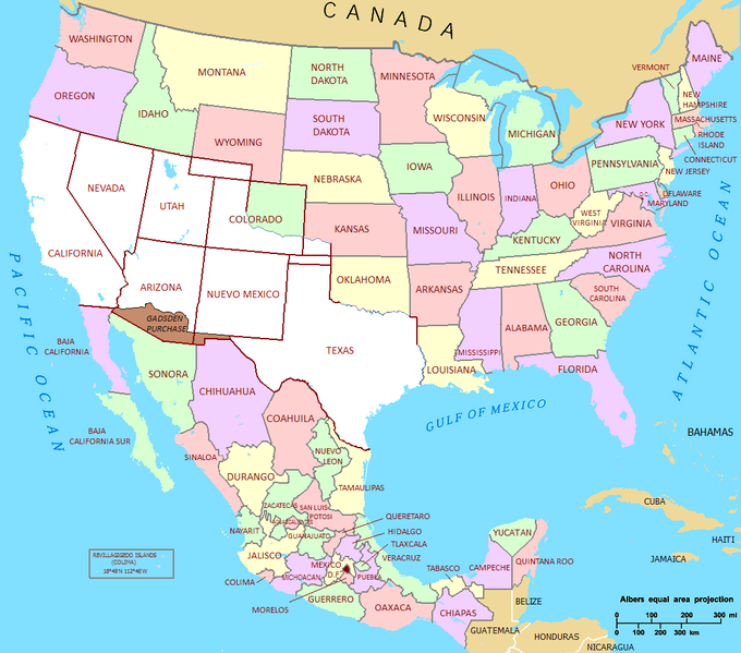
| Soat-bêng | Mexican Cession in Mexican View |
| Ji̍t-kî | 01/07/2009 |
| Chhut-chhù | U.S._Territorial_Acquisitions.png |
| Chok-chiá | United States federal government (en:User:Black and White converted it from JPEG to PNG and retouched it) |
| 授權允准 (Bô siŏh-huòi sāi ciā ùng-giông) |
This map was obtained from an edition of the National Atlas of the United States. Like almost all works of the U.S. federal government, works from the National Atlas are in the public domain. |
Siū-khoân
| 我,此作品的版權所有人,釋出此作品至公共領域。此授權條款在全世界均適用。 這可能在某些國家不合法,如果是的話: 我授予任何人有權利使用此作品於任何用途,除受法律約束外,不受任何限制。 |
Tóng-àn le̍k-sú
Chhi̍h ji̍t-kî/sî-kan, khoàⁿ hit sî-chūn--ê tóng-àn.
| Ji̍t-kî/Sî-kan | 細張圖 | 寸尺 | Iōng-chiá | Chù-kái | |
|---|---|---|---|---|---|
| hiān-chāi | 2011-nî 9-goe̍h 22-ji̍t (pài-sì) 21:02 | | 1,068 × 941(135 KB) | Hpav7 | ajustes |
| 2010-nî 1-goe̍h 18-ji̍t (pài-it) 04:39 |  | 1,068 × 941(135 KB) | Jaimiko | Se agrego la totalidad del territorio Mexicano y la division de los estados de Mexico. Was added the entire Mexican territory and the division of states of Mexico. | |
| 2009-nî 7-goe̍h 1-ji̍t (pài-saⁿ) 21:59 |  | 1,066 × 721(107 KB) | Jaimiko | {{Information |Description= Mexican Cession in Mexican View |Source= U.S._Territorial_Acquisitions.png |Date= 01/07/2009 |Author=United States federal government (en:User:Black and White converted it from JPEG to PNG and retouched it) |Permission=This map |
Iáⁿ-siōng liân-kiat
Í-hā ê ia̍h liân kàu chit ê iáⁿ-siōng:
tóng-àn hō͘ lâng sái--ê chōng-hóng
Ē-kha--ê kî-thaⁿ wiki ēng tio̍h chit--ê tóng-àn:
- af.wikipedia.org hō͘ lâng ēng--ê chêng-hêng
- ca.wikipedia.org hō͘ lâng ēng--ê chêng-hêng
- cs.wikipedia.org hō͘ lâng ēng--ê chêng-hêng
- de.wikipedia.org hō͘ lâng ēng--ê chêng-hêng
- en.wikipedia.org hō͘ lâng ēng--ê chêng-hêng
- es.wikipedia.org hō͘ lâng ēng--ê chêng-hêng
- fa.wikipedia.org hō͘ lâng ēng--ê chêng-hêng
- fi.wikipedia.org hō͘ lâng ēng--ê chêng-hêng
- fr.wikipedia.org hō͘ lâng ēng--ê chêng-hêng
- hr.wikipedia.org hō͘ lâng ēng--ê chêng-hêng
- hu.wikipedia.org hō͘ lâng ēng--ê chêng-hêng
- it.wikipedia.org hō͘ lâng ēng--ê chêng-hêng
- ja.wikipedia.org hō͘ lâng ēng--ê chêng-hêng
- ms.wikipedia.org hō͘ lâng ēng--ê chêng-hêng
- sh.wikipedia.org hō͘ lâng ēng--ê chêng-hêng
- ta.wikipedia.org hō͘ lâng ēng--ê chêng-hêng
- th.wikipedia.org hō͘ lâng ēng--ê chêng-hêng
- zh.wikipedia.org hō͘ lâng ēng--ê chêng-hêng