tóng-àn:Ph locator map palawan.png
Ph_locator_map_palawan.png (300 × 440 siōng-sò͘ , tóng-àn chiàm-liōng: 26 KB, MIME luī-hêng: image/png)
|
|
Che sī tùi Wikimedia Commons ín--lâi ê chi̍t hūn tóng-àn. I tī hia ê kì-su̍t-ia̍h téng-bīn ê chu-sìn hián-sī ùi ē-té. |
Khài-iàu
| Soat-bêng |
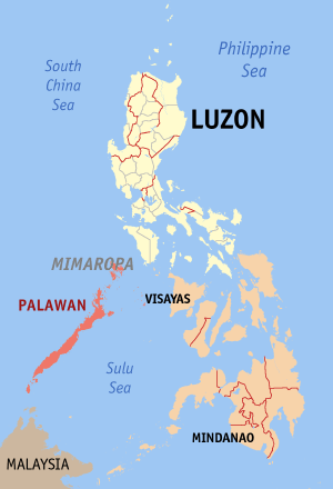
English: Map of the Philippines showing the location of Palawan. Red shade: Palawan Province; Light shade: Luzon Island Group; Orange: Rest of the Philippines |
| Ji̍t-kî | |
| Chhut-chhù | English Wikipedia |
| Chok-chiá | Eugene Alvin Villar (seav) |
Siū-khoân

|
已授權您依據自由軟體基金會發行的無固定段落、封面文字和封底文字GNU自由文件授權條款1.2版或任意後續版本,對本檔進行複製、傳播和/或修改。該協議的副本列在GNU自由文件授權條款中。 |
| 此檔案採用創用CC 姓名標示-相同方式分享 3.0 未在地化版本授權條款。 | ||
| ||
| 已新增授權條款標題至此檔案,作為GFDL授權更新的一部份。 |

|
If you choose to use this work under the Creative Commons license stated on this page, the author, Eugene Alvin Villar (seav), would like you to attribute the work to him (among other requirements such as indicating that the work is licensed under the Creative Commons) with the following text or similar:
© Eugene Alvin Villar, 2003
His name should be a link to his Wikimedia Commons userpage. If a link is not possible, then the url should be placed in parentheses after the name. If the work has been substantially altered by other people (see the File history section below), then this particular attribution requirement is waived, which means you can attribute the work in any reasonable manner. This attribution requirement is provided pursuant to the Creative Commons Attribution mechanism where "you must attribute the work in the manner specified by the author or licensor (but not in any way that suggests that they endorse you or your use of the work)." (See "Attribution" in the Creative Commons website.)
|
Tóng-àn le̍k-sú
Chhi̍h ji̍t-kî/sî-kan, khoàⁿ hit sî-chūn--ê tóng-àn.
| Ji̍t-kî/Sî-kan | 細張圖 | 寸尺 | Iōng-chiá | Chù-kái | |
|---|---|---|---|---|---|
| hiān-chāi | 2009-nî 7-goe̍h 1-ji̍t (pài-saⁿ) 13:28 | | 300 × 440(26 KB) | Hariboneagle927 | Palawan is in the MIMAROPA region references: http://en.wikipedia.org/wiki/MIMAROPA |
| 2005-nî 12-goe̍h 30-ji̍t (pài-gō·) 13:53 |  | 300 × 440(19 KB) | Magalhães | Map of the Philippines showing the location of Palawan. Created and copyright (2003) by seav. Released under the GNU FDL. | |
| 2005-nî 8-goe̍h 18-ji̍t (pài-sì) 20:45 |  | 300 × 450(15 KB) | Gildemax | Map of the Philippines showing the location of Palawan. Map of the Philippines showing the location of Palawan. Created and copyright (2003) by [[:en:user:]seav]]Released under the GNU FDL. Source: http://en.wikipedia.org/wiki/Image:Ph_locator_map_pal |
Iáⁿ-siōng liân-kiat
Bô poàⁿ ia̍h liân kàu chit tiuⁿ iáⁿ-siōng.
tóng-àn hō͘ lâng sái--ê chōng-hóng
Ē-kha--ê kî-thaⁿ wiki ēng tio̍h chit--ê tóng-àn:
- nl.wikipedia.org hō͘ lâng ēng--ê chêng-hêng