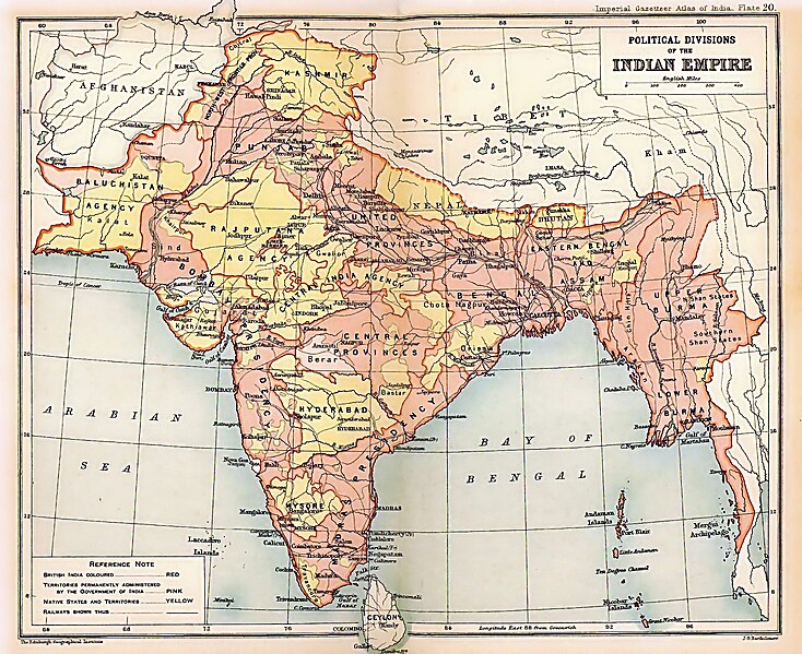
tóng-àn:British Indian Empire 1909 Imperial Gazetteer of India.jpg

Seng khoàⁿ chiàm-liōng: 734 × 599 siōng-sò͘. Kî-thaⁿ--ê kái-sek-tō͘: 294 × 240 siōng-sò͘ | 588 × 480 siōng-sò͘ | 941 × 768 siōng-sò͘ | 1,254 × 1,024 siōng-sò͘ | 1,498 × 1,223 siōng-sò͘.
Choân kái-sek-tō͘ (1,498 × 1,223 siōng-sò͘ , tóng-àn chiàm-liōng: 957 KB, MIME luī-hêng: image/jpeg)
Tóng-àn le̍k-sú
Chhi̍h ji̍t-kî/sî-kan, khoàⁿ hit sî-chūn--ê tóng-àn.
| Ji̍t-kî/Sî-kan | Sáuk-liŏk-dù | Chióh-cháung | Iōng-chiá | Chù-kái | |
|---|---|---|---|---|---|
| hiān-chāi | 2012-nî 3-goe̍h 15-ji̍t (pài-sì) 20:26 |  | 1,498 × 1,223(957 KB) | Soerfm | Color |
| 2012-nî 3-goe̍h 15-ji̍t (pài-sì) 20:28 |  | 1,498 × 1,223(1.53 MB) | Soerfm | Color | |
| 2012-nî 2-goe̍h 8-ji̍t (pài-saⁿ) 22:55 |  | 1,498 × 1,223(957 KB) | M0tty | Remove compression artefacts by a bilateral filtering. | |
| 2010-nî 5-goe̍h 23-ji̍t (lé-pài) 16:33 |  | 1,498 × 1,223(694 KB) | Malus Catulus | removed watermark | |
| 2009-nî 7-goe̍h 24-ji̍t (pài-gō·) 23:13 |  | 1,498 × 1,223(457 KB) | BetacommandBot | move approved by: User:Kintetsubuffalo This image was moved from File:IGI british indian empire1909reduced.jpg {{BotMoveToCommons|en.wikipedia|year=2008|month=October |day=13}} {{Information |Description={{en|Image of map of the British Indian |
Iáⁿ-siōng liân-kiat
Í-hā ê ia̍h liân kàu chit ê iáⁿ-siōng:
tóng-àn hō͘ lâng sái--ê chōng-hóng
Ē-kha--ê kî-thaⁿ wiki ēng tio̍h chit--ê tóng-àn:
- af.wikipedia.org hō͘ lâng ēng--ê chêng-hêng
- ar.wikipedia.org hō͘ lâng ēng--ê chêng-hêng
- arz.wikipedia.org hō͘ lâng ēng--ê chêng-hêng
- ast.wikipedia.org hō͘ lâng ēng--ê chêng-hêng
- as.wikipedia.org hō͘ lâng ēng--ê chêng-hêng
- azb.wikipedia.org hō͘ lâng ēng--ê chêng-hêng
- az.wikipedia.org hō͘ lâng ēng--ê chêng-hêng
- ba.wikipedia.org hō͘ lâng ēng--ê chêng-hêng
- be-tarask.wikipedia.org hō͘ lâng ēng--ê chêng-hêng
- be.wikipedia.org hō͘ lâng ēng--ê chêng-hêng
- bg.wikipedia.org hō͘ lâng ēng--ê chêng-hêng
- bh.wikipedia.org hō͘ lâng ēng--ê chêng-hêng
- bn.wikipedia.org hō͘ lâng ēng--ê chêng-hêng
- ca.wikipedia.org hō͘ lâng ēng--ê chêng-hêng
- ce.wikipedia.org hō͘ lâng ēng--ê chêng-hêng
- ckb.wikipedia.org hō͘ lâng ēng--ê chêng-hêng
- cs.wikipedia.org hō͘ lâng ēng--ê chêng-hêng
- cy.wikipedia.org hō͘ lâng ēng--ê chêng-hêng
- da.wikipedia.org hō͘ lâng ēng--ê chêng-hêng
- de.wikipedia.org hō͘ lâng ēng--ê chêng-hêng
檢視此檔案的更多全域使用狀況。
