tóng-àn:Eurasian steppe belt.jpg
Seng khoàⁿ chiàm-liōng: 800 × 597 siōng-sò͘. Kî-thaⁿ--ê kái-sek-tō͘: 320 × 239 siōng-sò͘ | 640 × 478 siōng-sò͘ | 1,024 × 765 siōng-sò͘ | 1,280 × 956 siōng-sò͘ | 2,048 × 1,529 siōng-sò͘.
Choân kái-sek-tō͘ (2,048 × 1,529 siōng-sò͘ , tóng-àn chiàm-liōng: 1.62 MB, MIME luī-hêng: image/jpeg)
|
|
Che sī tùi Wikimedia Commons ín--lâi ê chi̍t hūn tóng-àn. I tī hia ê kì-su̍t-ia̍h téng-bīn ê chu-sìn hián-sī ùi ē-té. |
Khài-iàu
| Soat-bêng |
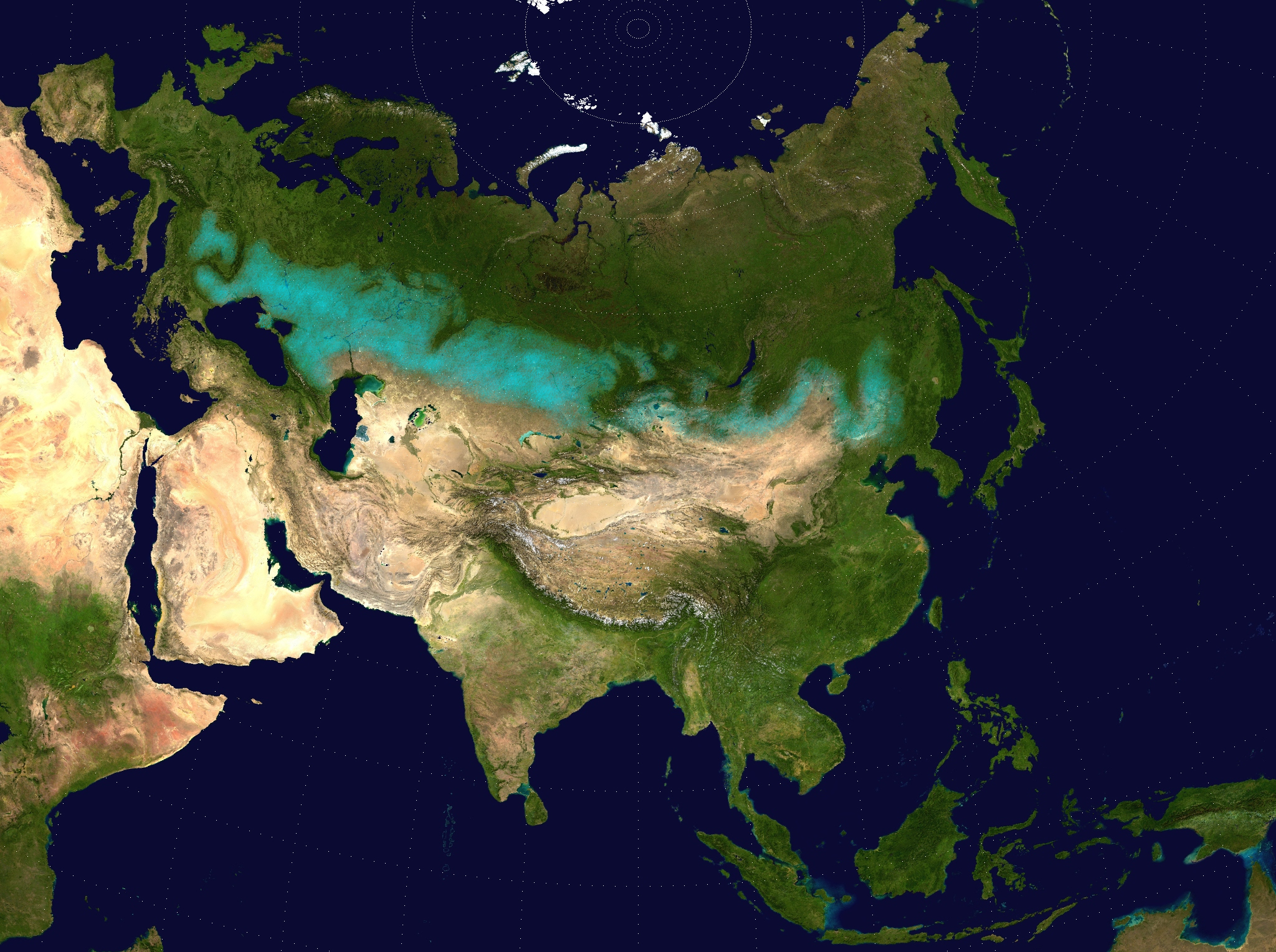
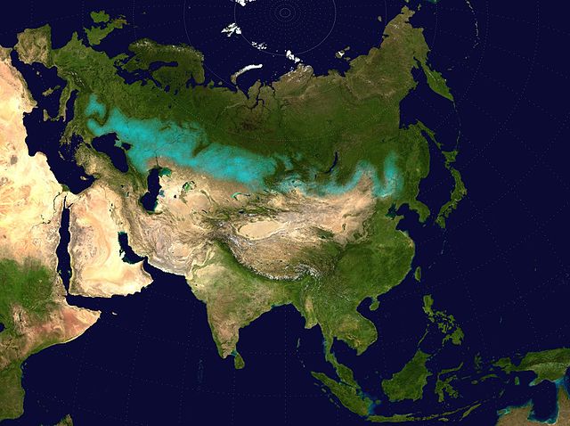
English: Approximate extent of the Eurasian Steppe grasslands ecoregion, and Eurasia cultural region.
|
| Ji̍t-kî | (UTC) |
| Chhut-chhù | |
| Chok-chiá |
|
| 授權允准 (Bô siŏh-huòi sāi ciā ùng-giông) |
Source map released into public domain. |
| 這是一張修飾過的圖片,即本圖片是用軟體修改過後的版本,修改的方式或內容有:Eurasian Steppe highlighted in ; areas of Caspian Sea and Lake Balkhash converted to to avoid confusion; image cropped.。原版圖片來源:Two-point-equidistant-asia.jpg。
|
Siū-khoân
我,本作品的著作權持有者,決定用以下授權條款發佈本作品:
| 我,此作品的版權所有人,釋出此作品至公共領域。此授權條款在全世界均適用。 這可能在某些國家不合法,如果是的話: 我授予任何人有權利使用此作品於任何用途,除受法律約束外,不受任何限制。 |
Tóng-àn le̍k-sú
Chhi̍h ji̍t-kî/sî-kan, khoàⁿ hit sî-chūn--ê tóng-àn.
| Ji̍t-kî/Sî-kan | Sáuk-liŏk-dù | Chióh-cháung | Iōng-chiá | Chù-kái | |
|---|---|---|---|---|---|
| hiān-chāi | 2017-nî 4-goe̍h 6-ji̍t (pài-sì) 17:24 | | 2,048 × 1,529(1.62 MB) | Clivius | The area was adjusted in accordance with the actual geographic location. |
| 2016-nî 6-goe̍h 10-ji̍t (pài-gō·) 00:48 |  | 1,640 × 1,320(296 KB) | Shattered Gnome | New coloration of source image; DarkPink highlight is now Cyan. Somewhat cropped. | |
| 2009-nî 5-goe̍h 26-ji̍t (pài-jī) 14:37 |  | 2,048 × 1,529(1.64 MB) | Cp6 | {{Information |Description=Approximate pathway of the Eurasian steppe belt. Based on file Two-point-equidistant-asia, see below. |Source=*File:Two-point-equidistant-asia.jpg |Date=2009-05-26 15:24 (UTC) |Author=*[[:File:Two-point-equidistant-asia.j |
Iáⁿ-siōng liân-kiat
Í-hā ê ia̍h liân kàu chit ê iáⁿ-siōng:
tóng-àn hō͘ lâng sái--ê chōng-hóng
Ē-kha--ê kî-thaⁿ wiki ēng tio̍h chit--ê tóng-àn:
- ar.wikipedia.org hō͘ lâng ēng--ê chêng-hêng
- azb.wikipedia.org hō͘ lâng ēng--ê chêng-hêng
- az.wikipedia.org hō͘ lâng ēng--ê chêng-hêng
- ba.wikipedia.org hō͘ lâng ēng--ê chêng-hêng
- be-tarask.wikipedia.org hō͘ lâng ēng--ê chêng-hêng
- be.wikipedia.org hō͘ lâng ēng--ê chêng-hêng
- bg.wikipedia.org hō͘ lâng ēng--ê chêng-hêng
- bh.wikipedia.org hō͘ lâng ēng--ê chêng-hêng
- bn.wikipedia.org hō͘ lâng ēng--ê chêng-hêng
- ca.wikipedia.org hō͘ lâng ēng--ê chêng-hêng
- cs.wikipedia.org hō͘ lâng ēng--ê chêng-hêng
- cy.wikipedia.org hō͘ lâng ēng--ê chêng-hêng
- de.wikipedia.org hō͘ lâng ēng--ê chêng-hêng
- de.wikibooks.org hō͘ lâng ēng--ê chêng-hêng
- de.wikiversity.org hō͘ lâng ēng--ê chêng-hêng
- el.wikipedia.org hō͘ lâng ēng--ê chêng-hêng
- en.wikipedia.org hō͘ lâng ēng--ê chêng-hêng
- eo.wikipedia.org hō͘ lâng ēng--ê chêng-hêng
- es.wikipedia.org hō͘ lâng ēng--ê chêng-hêng
- eu.wikipedia.org hō͘ lâng ēng--ê chêng-hêng
- fa.wikipedia.org hō͘ lâng ēng--ê chêng-hêng
- fa.wikibooks.org hō͘ lâng ēng--ê chêng-hêng
- fi.wikipedia.org hō͘ lâng ēng--ê chêng-hêng
- frr.wikipedia.org hō͘ lâng ēng--ê chêng-hêng
- fr.wikivoyage.org hō͘ lâng ēng--ê chêng-hêng
- ga.wikipedia.org hō͘ lâng ēng--ê chêng-hêng
- glk.wikipedia.org hō͘ lâng ēng--ê chêng-hêng
- he.wikipedia.org hō͘ lâng ēng--ê chêng-hêng
- hi.wikipedia.org hō͘ lâng ēng--ê chêng-hêng
- hr.wikipedia.org hō͘ lâng ēng--ê chêng-hêng
- hu.wikipedia.org hō͘ lâng ēng--ê chêng-hêng
- hy.wikipedia.org hō͘ lâng ēng--ê chêng-hêng
檢視此檔案的更多全域使用狀況。