tóng-àn:Nottinghamshire UK location map.svg

此 SVG 檔案的 PNG 預覽的大小:473 × 599 siōng-sò͘。 Kî-thaⁿ--ê kái-sek-tō͘: 189 × 240 siōng-sò͘ | 379 × 480 siōng-sò͘ | 606 × 768 siōng-sò͘ | 808 × 1,024 siōng-sò͘ | 1,616 × 2,048 siōng-sò͘ | 1,030 × 1,305 siōng-sò͘.
Choân kái-sek-tō͘ (SVG ùng-giông, chék-cháung: 1,030 × 1,305 chuông-só, ùng-giông duâi-nâung:1.95 MB)
|
|
Che sī tùi Wikimedia Commons ín--lâi ê chi̍t hūn tóng-àn. I tī hia ê kì-su̍t-ia̍h téng-bīn ê chu-sìn hián-sī ùi ē-té. |
| Soat-bêng |
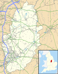
Map of Nottinghamshire, UK with the following information shown:
Equirectangular map projection on WGS 84 datum, with N/S stretched 165% Geographic limits:
|
| Ji̍t-kî | |
| Chhut-chhù |
|
| Chok-chiá | Nilfanion, created using Ordnance Survey data |
| 授權允准 (Bô siŏh-huòi sāi ciā ùng-giông) |
此檔案採用創用CC 姓名標示-相同方式分享 3.0 未在地化版本授權條款。 Biĕu-sê miàng-sáng: Contains Ordnance Survey data © Crown copyright and database right
|
| 其他版本 | File:Nottinghamshire UK district map (blank).svg - Blank map |
.svg)
Tóng-àn le̍k-sú
Chhi̍h ji̍t-kî/sî-kan, khoàⁿ hit sî-chūn--ê tóng-àn.
| Ji̍t-kî/Sî-kan | Sáuk-liŏk-dù | Chióh-cháung | Iōng-chiá | Chù-kái | |
|---|---|---|---|---|---|
| hiān-chāi | 2010-nî 9-goe̍h 26-ji̍t (lé-pài) 19:09 | | 1,030 × 1,305(1.95 MB) | Nilfanion | {{Information |Description=Map of Nottinghamshire, UK with the following information shown: *Administrative borders *Coastline, lakes and rivers *Roads and railways *Urban areas Equirectangular map projection on WGS 84 datum, with N |
Iáⁿ-siōng liân-kiat
超過 100 個頁面有用到此檔案。 下列清單只列出前 100 筆有用到此檔案的頁面。 您也可以檢視完整清單。
- Alverton
- Annesley
- Askham (Nottinghamshire)
- Aslockton
- Averham
- Awsworth
- Babworth
- Balderton
- Barnby Moor
- Barnby in the Willows
- Barton in Fabis
- Bathley
- Beckingham (Nottinghamshire)
- Beeston (Nottinghamshire)
- Bestwood St Albans
- Bevercotes
- Bingham (Nottinghamshire)
- Bleasby
- Blidworth
- Blyth (Nottinghamshire)
- Bothamsall
- Bradmore
- Brinsley
- Bulcote
- Bunny
- Burton Joyce
- Calverton (Nottinghamshire)
- Carlton-on-Trent
- Carlton in Lindrick
- Clipston on the Wolds
- Clipstone
- Coddington (Nottinghamshire)
- Collingham (Nottinghamshire)
- Colwick
- Cossall
- Costock
- Cotgrave
- Cromwell (Nottinghamshire)
- Cropwell Bishop
- Cropwell Butler
- Darlton
- Eakring
- East Drayton
- East Leake
- East Markham
- East Stoke (Nottinghamshire)
- Eastwood (Nottinghamshire)
- Edingley
- Edwinstowe
- Egmanton
- Elkesley
- Flawborough
- Fledborough
- Gamston
- Girton (Nottinghamshire)
- Gotham (Nottinghamshire)
- Greasley
- Halam
- Halloughton
- Harby (Nottinghamshire)
- Harworth
- Hawksworth
- Hayton (Nottinghamshire)
- Hickling (Nottinghamshire)
- Hodsock
- Holbeck (Nottinghamshire)
- Holme (Nottinghamshire)
- Kersall
- Keyworth
- Kilvington
- Kimberley (Nottinghamshire)
- Kingston on Soar
- Kinoulton
- Kirkby-in-Ashfield
- Kirton (Nottinghamshire)
- Lambley
- Linby
- Lound (Nottinghamshire)
- Lowdham
- Mansfield Woodhouse
- Maplebeck
- Mattersey
- Misson (Nottinghamshire)
- Misterton (Nottinghamshire)
- Nether Langwith
- Newark-on-Trent
- Normanton-on-the-Wolds
- Normanton on Soar
- Normanton on Trent
- North Clifton
- Ompton
- Oxton (Nottinghamshire)
- Papplewick
- Radcliffe on Trent
- Ragnall
- Rainworth
- Rampton (Nottinghamshire)
- Ranskill
- Ratcliffe-on-Soar
- Rempstone
檢視連結到這個檔案的更多連結。
tóng-àn hō͘ lâng sái--ê chōng-hóng
Ē-kha--ê kî-thaⁿ wiki ēng tio̍h chit--ê tóng-àn:
- ar.wikipedia.org hō͘ lâng ēng--ê chêng-hêng
- bg.wikipedia.org hō͘ lâng ēng--ê chêng-hêng
- br.wikipedia.org hō͘ lâng ēng--ê chêng-hêng
- ceb.wikipedia.org hō͘ lâng ēng--ê chêng-hêng
- en.wikipedia.org hō͘ lâng ēng--ê chêng-hêng
- Newstead Abbey
- Beeston, Nottinghamshire
- Blyth, Nottinghamshire
- Worksop
- Newark-on-Trent
- Edwinstowe
- Nottingham Castle
- Gotham, Nottinghamshire
- Eastwood, Nottinghamshire
- Retford
- Ollerton
- Kimberley, Nottinghamshire
- The Park Estate
- Sutton Bonington
- Queen's Medical Centre
- Calverton, Nottinghamshire
- Wollaton Hall
- Hucknall
- Arnold, Nottinghamshire
- Bircotes
- Manton, Nottinghamshire
- Scrooby
- Carlton, Nottinghamshire
- Bingham, Nottinghamshire
- West Bridgford
- Sutton-in-Ashfield
- Gamston, Rushcliffe
- Cotgrave
- RAF Syerston
- Blidworth
- Lenton, Nottingham
- Kirkby-in-Ashfield
- Tollerton, Nottinghamshire
- Rampton Secure Hospital
- Holme Pierrepont
- Zouch
- Nottingham station
- Mansfield Woodhouse
- Toton
- Redhill, Nottinghamshire
- Aslockton
- Clumber Park
- Spion Kop, Nottinghamshire
- Chilwell
- Radford, Nottingham
檢視此檔案的更多全域使用狀況。