tóng-àn:Red Sea topographic map-en.jpg

Seng khoàⁿ chiàm-liōng: 367 × 600 siōng-sò͘. Kî-thaⁿ--ê kái-sek-tō͘: 147 × 240 siōng-sò͘ | 293 × 480 siōng-sò͘ | 470 × 768 siōng-sò͘ | 626 × 1,024 siōng-sò͘ | 1,655 × 2,705 siōng-sò͘.
Choân kái-sek-tō͘ (1,655 × 2,705 siōng-sò͘ , tóng-àn chiàm-liōng: 1.63 MB, MIME luī-hêng: image/jpeg)
|
|
Che sī tùi Wikimedia Commons ín--lâi ê chi̍t hūn tóng-àn. I tī hia ê kì-su̍t-ia̍h téng-bīn ê chu-sìn hián-sī ùi ē-té. |
Khài-iàu
| 拍攝地點 | | 位於此地的本圖片與其他圖片: OpenStreetMap |
|---|
| Soat-bêng |
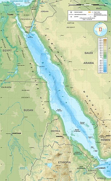
English: Topographic map in English of the Red Sea, UTM projection (WGS84 datum).
Note : for translation purpose, use the SVG version. Français : Carte topographique en anglais de la Mer Rouge, projection UTM (WGS84 datum).
|
||
| Ji̍t-kî | |||
| Chhut-chhù | Own work (see complete description on Image:Red_Sea_topographic_map-en.svg) | ||
| Chok-chiá | Eric Gaba (Sting - fr:Sting) | ||
| 授權允准 (Bô siŏh-huòi sāi ciā ùng-giông) |
|
||
| 其他版本 |
[]
|


Siū-khoân
我,本作品的著作權持有者,決定用以下授權條款發佈本作品:

|
已授權您依據自由軟體基金會發行的無固定段落、封面文字和封底文字GNU自由文件授權條款1.2版或任意後續版本,對本檔進行複製、傳播和/或修改。該協議的副本列在GNU自由文件授權條款中。 |
This file is licensed under the Creative Commons Attribution-Share Alike 4.0 International, 3.0 Unported, 2.5 Generic, 2.0 Generic and 1.0 Generic license.
- 你會使自由:
- 分享 – kho͘-pih, hoat-pò͘ kap thoân-pò͘ pún chok
- 重新修改 – kái-pian pún chok-phín
- Àn i-hā ê tiâu-kiāⁿ
- 標示名姓 – 您必須指名出正確的製作者,和提供授權條款的連結,以及表示是否有對內容上做出變更。您可以用任何合理的方式來行動,但不得以任何方式表明授權條款是對您許可或是由您所使用。
- 仝款方式方享 – Lí nā kái-tōng, piàn-khoán, he̍k-chiá kun-kù pún chok chhòng-chō, lí kaⁿ-taⁿ ē-tàng ēng kap pún chok kâng-khoán he̍k-chiá saⁿ-chhiūⁿ ê hí-khó lâi hoat-pò͘ chò--chhut-lâi ê chok-phín.
Nṳ̄ buóh dĭk sié-nó̤h sêu-guòng dèu-kuāng dŭ kō̤-ī gēng.
Tóng-àn le̍k-sú
Chhi̍h ji̍t-kî/sî-kan, khoàⁿ hit sî-chūn--ê tóng-àn.
| Ji̍t-kî/Sî-kan | Sáuk-liŏk-dù | Chióh-cháung | Iōng-chiá | Chù-kái | |
|---|---|---|---|---|---|
| hiān-chāi | 2023-nî 12-goe̍h 29-ji̍t (pài-gō·) 15:40 | | 1,655 × 2,705(1.63 MB) | Sting | Without frame |
| 2010-nî 7-goe̍h 19-ji̍t (pài-it) 13:37 |  | 1,655 × 2,705(1.68 MB) | Sting | Color profile | |
| 2008-nî 9-goe̍h 2-ji̍t (pài-jī) 04:47 |  | 1,655 × 2,705(1.6 MB) | Sting | New standard colors ; bathymetry from ETOPO1 ; etc. | |
| 2008-nî 4-goe̍h 3-ji̍t (pài-sì) 19:35 |  | 1,655 × 2,705(1.67 MB) | Sting | Additional corrections | |
| 2008-nî 4-goe̍h 3-ji̍t (pài-sì) 13:09 |  | 1,655 × 2,705(1.71 MB) | Sting | Some names corrections ; some improvements | |
| 2008-nî 4-goe̍h 3-ji̍t (pài-sì) 11:26 |  | 1,655 × 2,705(1.67 MB) | Sting | Little correction | |
| 2008-nî 4-goe̍h 2-ji̍t (pài-saⁿ) 22:32 |  | 1,655 × 2,705(1.7 MB) | Sting | {{Location|21|00|00|N|38|00|00|E|scale:10000000}} <br/> {{Information |Description={{en|Topographic map in English of the red Sea<br/>''Note :'' for translation purpose, use the SVG version.}} {{fr |
Iáⁿ-siōng liân-kiat
Í-hā ê ia̍h liân kàu chit ê iáⁿ-siōng:
- Âng-hái
- Wikipedia:Chin-chán ê bûn-chiuⁿ
- Wikipedia:Súi-khùi ê bûn-chiuⁿ
- Wikipedia:Súi-khùi ê bûn-chiuⁿ/10 goe̍h
- Wikipedia:Súi-khùi ê bûn-chiuⁿ/10 goe̍h 19 ji̍t
- Wikipedia:Súi-khùi ê bûn-chiuⁿ/10 goe̍h 3 ji̍t
- Wikipedia:Súi-khùi ê bûn-chiuⁿ/11 goe̍h
- Wikipedia:Súi-khùi ê bûn-chiuⁿ/11 goe̍h 20 ji̍t
- Wikipedia:Súi-khùi ê bûn-chiuⁿ/11 goe̍h 4 ji̍t
- Wikipedia:Súi-khùi ê bûn-chiuⁿ/12 goe̍h
- Wikipedia:Súi-khùi ê bûn-chiuⁿ/12 goe̍h 22 ji̍t
- Wikipedia:Súi-khùi ê bûn-chiuⁿ/12 goe̍h 6 ji̍t
- Wikipedia:Súi-khùi ê bûn-chiuⁿ/1 goe̍h
- Wikipedia:Súi-khùi ê bûn-chiuⁿ/1 goe̍h 21 ji̍t
- Wikipedia:Súi-khùi ê bûn-chiuⁿ/1 goe̍h 5 ji̍t
- Wikipedia:Súi-khùi ê bûn-chiuⁿ/2 goe̍h
- Wikipedia:Súi-khùi ê bûn-chiuⁿ/2 goe̍h 22 ji̍t
- Wikipedia:Súi-khùi ê bûn-chiuⁿ/2 goe̍h 6 ji̍t
- Wikipedia:Súi-khùi ê bûn-chiuⁿ/3 goe̍h
- Wikipedia:Súi-khùi ê bûn-chiuⁿ/3 goe̍h 25 ji̍t
- Wikipedia:Súi-khùi ê bûn-chiuⁿ/3 goe̍h 9 ji̍t
- Wikipedia:Súi-khùi ê bûn-chiuⁿ/4 goe̍h
- Wikipedia:Súi-khùi ê bûn-chiuⁿ/4 goe̍h 10 ji̍t
- Wikipedia:Súi-khùi ê bûn-chiuⁿ/4 goe̍h 26 ji̍t
- Wikipedia:Súi-khùi ê bûn-chiuⁿ/5 goe̍h
- Wikipedia:Súi-khùi ê bûn-chiuⁿ/5 goe̍h 12 ji̍t
- Wikipedia:Súi-khùi ê bûn-chiuⁿ/5 goe̍h 28 ji̍t
- Wikipedia:Súi-khùi ê bûn-chiuⁿ/6 goe̍h
- Wikipedia:Súi-khùi ê bûn-chiuⁿ/6 goe̍h 13 ji̍t
- Wikipedia:Súi-khùi ê bûn-chiuⁿ/6 goe̍h 29 ji̍t
- Wikipedia:Súi-khùi ê bûn-chiuⁿ/7 goe̍h
- Wikipedia:Súi-khùi ê bûn-chiuⁿ/7 goe̍h 15 ji̍t
- Wikipedia:Súi-khùi ê bûn-chiuⁿ/7 goe̍h 31 ji̍t
- Wikipedia:Súi-khùi ê bûn-chiuⁿ/8 goe̍h
- Wikipedia:Súi-khùi ê bûn-chiuⁿ/8 goe̍h 16 ji̍t
- Wikipedia:Súi-khùi ê bûn-chiuⁿ/9 goe̍h
- Wikipedia:Súi-khùi ê bûn-chiuⁿ/9 goe̍h 17 ji̍t
- Wikipedia:Súi-khùi ê bûn-chiuⁿ/9 goe̍h 1 ji̍t
- Pang-bô͘:Iu-téng bûn-chiuⁿ/5 goe̍h
tóng-àn hō͘ lâng sái--ê chōng-hóng
Ē-kha--ê kî-thaⁿ wiki ēng tio̍h chit--ê tóng-àn:
- ami.wikipedia.org hō͘ lâng ēng--ê chêng-hêng
- am.wikipedia.org hō͘ lâng ēng--ê chêng-hêng
- ban.wikipedia.org hō͘ lâng ēng--ê chêng-hêng
- bg.wikipedia.org hō͘ lâng ēng--ê chêng-hêng
- bh.wikipedia.org hō͘ lâng ēng--ê chêng-hêng
- bn.wikipedia.org hō͘ lâng ēng--ê chêng-hêng
- ca.wikipedia.org hō͘ lâng ēng--ê chêng-hêng
- ckb.wikipedia.org hō͘ lâng ēng--ê chêng-hêng
- en.wikipedia.org hō͘ lâng ēng--ê chêng-hêng
- eu.wikipedia.org hō͘ lâng ēng--ê chêng-hêng
- fa.wikipedia.org hō͘ lâng ēng--ê chêng-hêng
- fa.wikivoyage.org hō͘ lâng ēng--ê chêng-hêng
- gu.wikipedia.org hō͘ lâng ēng--ê chêng-hêng
- hak.wikipedia.org hō͘ lâng ēng--ê chêng-hêng
- he.wikipedia.org hō͘ lâng ēng--ê chêng-hêng
- he.wiktionary.org hō͘ lâng ēng--ê chêng-hêng
- hi.wikipedia.org hō͘ lâng ēng--ê chêng-hêng
- hr.wikipedia.org hō͘ lâng ēng--ê chêng-hêng
- ilo.wikipedia.org hō͘ lâng ēng--ê chêng-hêng
- incubator.wikimedia.org hō͘ lâng ēng--ê chêng-hêng
- ja.wikipedia.org hō͘ lâng ēng--ê chêng-hêng
- ja.wikibooks.org hō͘ lâng ēng--ê chêng-hêng
- ka.wikipedia.org hō͘ lâng ēng--ê chêng-hêng
- kcg.wikipedia.org hō͘ lâng ēng--ê chêng-hêng
- kn.wikipedia.org hō͘ lâng ēng--ê chêng-hêng
- ko.wikipedia.org hō͘ lâng ēng--ê chêng-hêng
- lfn.wikipedia.org hō͘ lâng ēng--ê chêng-hêng
- lv.wikipedia.org hō͘ lâng ēng--ê chêng-hêng
- mai.wikipedia.org hō͘ lâng ēng--ê chêng-hêng
- ml.wikipedia.org hō͘ lâng ēng--ê chêng-hêng
- ms.wikipedia.org hō͘ lâng ēng--ê chêng-hêng
- my.wikipedia.org hō͘ lâng ēng--ê chêng-hêng
- ne.wikipedia.org hō͘ lâng ēng--ê chêng-hêng
- no.wikipedia.org hō͘ lâng ēng--ê chêng-hêng
- olo.wikipedia.org hō͘ lâng ēng--ê chêng-hêng
檢視此檔案的更多全域使用狀況。