tóng-àn:Thermohaline Circulation 2.png
Seng khoàⁿ chiàm-liōng: 800 × 502 siōng-sò͘. Kî-thaⁿ--ê kái-sek-tō͘: 320 × 201 siōng-sò͘ | 640 × 401 siōng-sò͘ | 1,100 × 690 siōng-sò͘.
Choân kái-sek-tō͘ (1,100 × 690 siōng-sò͘ , tóng-àn chiàm-liōng: 122 KB, MIME luī-hêng: image/png)
|
|
Che sī tùi Wikimedia Commons ín--lâi ê chi̍t hūn tóng-àn. I tī hia ê kì-su̍t-ia̍h téng-bīn ê chu-sìn hián-sī ùi ē-té. |
Khài-iàu
| Soat-bêng |
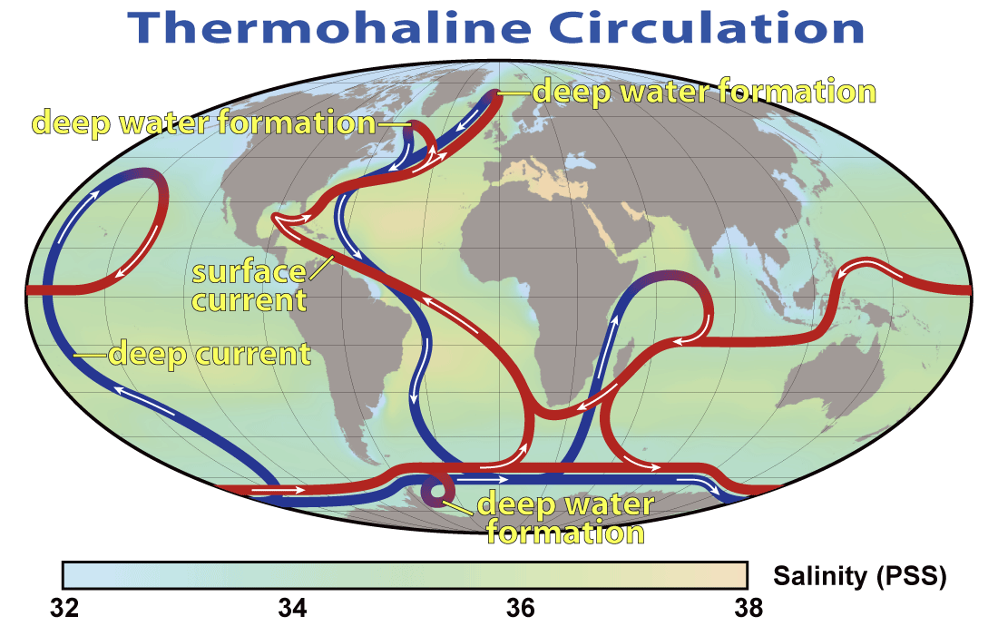
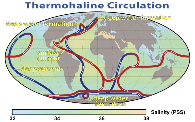
English: This map shows the pattern of thermohaline circulation also known as "meridional overturning circulation". This collection of currents is responsible for the large-scale exchange of water masses in the ocean, including providing oxygen to the deep ocean. The entire circulation pattern takes ~2000 years.
Deutsch: Thermohaline Zirkulation und die Entstehung von kaltem, dichtem Tiefenwasser im Nordmeer |
|||||
| Ji̍t-kî | ||||||
| Chhut-chhù | NASA Earth Observatory | |||||
| Chok-chiá | Robert Simmon, NASA. Minor modifications by Robert A. Rohde also released to the public domain | |||||
| 授權允准 (Bô siŏh-huòi sāi ciā ùng-giông) |
|
|||||
| 其他版本 |
 |


|
本圖片是以PNG、GIF或JPEG格式上傳。然而,其中包含的資料或訊息,應該重新建立成可縮放向量圖形(SVG)檔案,以更有效率或更準確的方式儲存。如有可能,請上傳本圖片的SVG格式版本。在上傳之後,請修改維基各姊妹計畫中所有使用舊版圖片的條目(列在圖像連結章節中),替換為新版圖片,並在舊圖片的描述頁中加入{{Vector version available|新圖片名稱.svg}}模板,同時移除本模板。
|
Tóng-àn le̍k-sú
Chhi̍h ji̍t-kî/sî-kan, khoàⁿ hit sî-chūn--ê tóng-àn.
| Ji̍t-kî/Sî-kan | Sáuk-liŏk-dù | Chióh-cháung | Iōng-chiá | Chù-kái | |
|---|---|---|---|---|---|
| hiān-chāi | 2008-nî 3-goe̍h 29-ji̍t (pài-la̍k) 20:08 | | 1,100 × 690(122 KB) | Dragons flight | {{Information |Description=This map shows the pattern of w:thermohaline circulation also known as "meridional overturning circulation". This collection of currents is responsible for the large-scale exchange of water masses in the ocean, including p |
Iáⁿ-siōng liân-kiat
Í-hā ê ia̍h liân kàu chit ê iáⁿ-siōng:
tóng-àn hō͘ lâng sái--ê chōng-hóng
Ē-kha--ê kî-thaⁿ wiki ēng tio̍h chit--ê tóng-àn:
- ar.wikipedia.org hō͘ lâng ēng--ê chêng-hêng
- ast.wikipedia.org hō͘ lâng ēng--ê chêng-hêng
- az.wikipedia.org hō͘ lâng ēng--ê chêng-hêng
- ba.wikipedia.org hō͘ lâng ēng--ê chêng-hêng
- bcl.wikipedia.org hō͘ lâng ēng--ê chêng-hêng
- be.wikipedia.org hō͘ lâng ēng--ê chêng-hêng
- bg.wikipedia.org hō͘ lâng ēng--ê chêng-hêng
- bh.wikipedia.org hō͘ lâng ēng--ê chêng-hêng
- bn.wikipedia.org hō͘ lâng ēng--ê chêng-hêng
- bs.wikipedia.org hō͘ lâng ēng--ê chêng-hêng
- bxr.wikipedia.org hō͘ lâng ēng--ê chêng-hêng
- ca.wikipedia.org hō͘ lâng ēng--ê chêng-hêng
- cdo.wikipedia.org hō͘ lâng ēng--ê chêng-hêng
- cs.wikipedia.org hō͘ lâng ēng--ê chêng-hêng
- da.wikipedia.org hō͘ lâng ēng--ê chêng-hêng
- da.wikibooks.org hō͘ lâng ēng--ê chêng-hêng
- de.wikipedia.org hō͘ lâng ēng--ê chêng-hêng
- el.wikipedia.org hō͘ lâng ēng--ê chêng-hêng
- en.wikipedia.org hō͘ lâng ēng--ê chêng-hêng
- en.wikibooks.org hō͘ lâng ēng--ê chêng-hêng
檢視此檔案的更多全域使用狀況。