tóng-àn:2007 01 23 - Stringtown@121@355@270 - WB 2.JPG

Seng khoàⁿ chiàm-liōng: 800 × 600 siōng-sò͘. Kî-thaⁿ--ê kái-sek-tō͘: 320 × 240 siōng-sò͘ | 640 × 480 siōng-sò͘ | 1,024 × 768 siōng-sò͘ | 1,280 × 960 siōng-sò͘ | 2,592 × 1,944 siōng-sò͘.
Choân kái-sek-tō͘ (2,592 × 1,944 siōng-sò͘ , tóng-àn chiàm-liōng: 1.33 MB, MIME luī-hêng: image/jpeg)
|
|
Che sī tùi Wikimedia Commons ín--lâi ê chi̍t hūn tóng-àn. I tī hia ê kì-su̍t-ia̍h téng-bīn ê chu-sìn hián-sī ùi ē-té. |
| Soat-bêng |
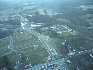
English: Stringtown Road runs from through the center from the bottom to the interchange near the top, where it continues on as MD 121 (Clarksburg Road) to the horizon. MD 121 splits toward the center-right, generally hidden behind trees. These roads interchange with I-270, which runs left to right, toward the top. The left-right roadway at the bottom is MD 355. Clarksburg, MD, USA
|
||||
| Ji̍t-kî | |||||
| Chhut-chhù | Ka-tī chò--ê | ||||
| Chok-chiá | Andrew Bossi | ||||
| 授權允准 (Bô siŏh-huòi sāi ciā ùng-giông) |
Own work, share alike, attribution required (Creative Commons CC-BY-SA-2.5) |
我,本作品的著作權持有者,決定用以下授權條款發佈本作品:
此檔案採用創用CC 姓名標示-相同方式分享 2.5 通用版授權條款。
- 你會使自由:
- 分享 – kho͘-pih, hoat-pò͘ kap thoân-pò͘ pún chok
- 重新修改 – kái-pian pún chok-phín
- Àn i-hā ê tiâu-kiāⁿ
- 標示名姓 – 您必須指名出正確的製作者,和提供授權條款的連結,以及表示是否有對內容上做出變更。您可以用任何合理的方式來行動,但不得以任何方式表明授權條款是對您許可或是由您所使用。
- 仝款方式方享 – Lí nā kái-tōng, piàn-khoán, he̍k-chiá kun-kù pún chok chhòng-chō, lí kaⁿ-taⁿ ē-tàng ēng kap pún chok kâng-khoán he̍k-chiá saⁿ-chhiūⁿ ê hí-khó lâi hoat-pò͘ chò--chhut-lâi ê chok-phín.
Tóng-àn le̍k-sú
Chhi̍h ji̍t-kî/sî-kan, khoàⁿ hit sî-chūn--ê tóng-àn.
| Ji̍t-kî/Sî-kan | 細張圖 | 寸尺 | Iōng-chiá | Chù-kái | |
|---|---|---|---|---|---|
| hiān-chāi | 2007-nî 11-goe̍h 15-ji̍t (pài-sì) 23:18 | | 2,592 × 1,944(1.33 MB) | Thisisbossi | {{Information |Description={{en|Stringtown Road runs from through the center from the bottom to the interchange near the top, where it continues on as MD 121 (Clarksburg Road) to the horizon. MD 121 splits toward the center-right, generally hidden behind |
Iáⁿ-siōng liân-kiat
Í-hā ê ia̍h liân kàu chit ê iáⁿ-siōng:
tóng-àn hō͘ lâng sái--ê chōng-hóng
Ē-kha--ê kî-thaⁿ wiki ēng tio̍h chit--ê tóng-àn:
- ar.wikipedia.org hō͘ lâng ēng--ê chêng-hêng
- azb.wikipedia.org hō͘ lâng ēng--ê chêng-hêng
- ca.wikipedia.org hō͘ lâng ēng--ê chêng-hêng
- ceb.wikipedia.org hō͘ lâng ēng--ê chêng-hêng
- en.wikipedia.org hō͘ lâng ēng--ê chêng-hêng
- es.wikipedia.org hō͘ lâng ēng--ê chêng-hêng
- eu.wikipedia.org hō͘ lâng ēng--ê chêng-hêng
- fa.wikipedia.org hō͘ lâng ēng--ê chêng-hêng
- it.wikipedia.org hō͘ lâng ēng--ê chêng-hêng
- ky.wikipedia.org hō͘ lâng ēng--ê chêng-hêng
- lld.wikipedia.org hō͘ lâng ēng--ê chêng-hêng
- pl.wikipedia.org hō͘ lâng ēng--ê chêng-hêng
- pt.wikipedia.org hō͘ lâng ēng--ê chêng-hêng
- sh.wikipedia.org hō͘ lâng ēng--ê chêng-hêng
- sr.wikipedia.org hō͘ lâng ēng--ê chêng-hêng
- tt.wikipedia.org hō͘ lâng ēng--ê chêng-hêng
- uk.wikipedia.org hō͘ lâng ēng--ê chêng-hêng
- ur.wikipedia.org hō͘ lâng ēng--ê chêng-hêng
- uz.wikipedia.org hō͘ lâng ēng--ê chêng-hêng
- www.wikidata.org hō͘ lâng ēng--ê chêng-hêng
- zh.wikipedia.org hō͘ lâng ēng--ê chêng-hêng