tóng-àn:Angels Landing.jpg

Seng khoàⁿ chiàm-liōng: 800 × 600 siōng-sò͘. Kî-thaⁿ--ê kái-sek-tō͘: 320 × 240 siōng-sò͘ | 640 × 480 siōng-sò͘ | 1,024 × 768 siōng-sò͘ | 1,280 × 960 siōng-sò͘ | 2,560 × 1,920 siōng-sò͘ | 3,648 × 2,736 siōng-sò͘.
Choân kái-sek-tō͘ (3,648 × 2,736 siōng-sò͘ , tóng-àn chiàm-liōng: 6.45 MB, MIME luī-hêng: image/jpeg)
|
|
Che sī tùi Wikimedia Commons ín--lâi ê chi̍t hūn tóng-àn. I tī hia ê kì-su̍t-ia̍h téng-bīn ê chu-sìn hián-sī ùi ē-té. |
Khài-iàu
| Soat-bêng |
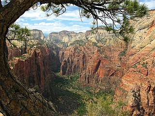
English: breathtaking view from the Angels Landing trail looking northward to the Narrows, Zion National Park, Utah, USA.
Français : Vue vers le nord depuis le Angels Landing trail sur the Narrows, à Zion National Park, en Utah (États-Unis). |
| Ji̍t-kî | 攝於2007年7-goe̍h14日 |
| Chhut-chhù | Ka-tī chò--ê |
| Chok-chiá | Tobias Alt |
| 拍攝地點 | | 位於此地的本圖片與其他圖片: OpenStreetMap |
|---|

|
根據最有價值圖像標準,這張圖像被評定为在Zion Canyon, Zion National Park, Utah範疇內最有價值的共享資源圖像。你可以在Commons:Valued image candidates/Angels Landing.jpg参看它的提名。 |
Siū-khoân
我,本作品的著作權持有者,決定用以下授權條款發佈本作品:

|
已授權您依據自由軟體基金會發行的無固定段落、封面文字和封底文字GNU自由文件授權條款1.2版或任意後續版本,對本檔進行複製、傳播和/或修改。該協議的副本列在GNU自由文件授權條款中。 |
This file is licensed under the Creative Commons Attribution-Share Alike 4.0 International, 3.0 Unported, 2.5 Generic, 2.0 Generic and 1.0 Generic license.
- 你會使自由:
- 分享 – kho͘-pih, hoat-pò͘ kap thoân-pò͘ pún chok
- 重新修改 – kái-pian pún chok-phín
- Àn i-hā ê tiâu-kiāⁿ
- 標示名姓 – 您必須指名出正確的製作者,和提供授權條款的連結,以及表示是否有對內容上做出變更。您可以用任何合理的方式來行動,但不得以任何方式表明授權條款是對您許可或是由您所使用。
- 仝款方式方享 – Lí nā kái-tōng, piàn-khoán, he̍k-chiá kun-kù pún chok chhòng-chō, lí kaⁿ-taⁿ ē-tàng ēng kap pún chok kâng-khoán he̍k-chiá saⁿ-chhiūⁿ ê hí-khó lâi hoat-pò͘ chò--chhut-lâi ê chok-phín.
Nṳ̄ buóh dĭk sié-nó̤h sêu-guòng dèu-kuāng dŭ kō̤-ī gēng.
Tóng-àn le̍k-sú
Chhi̍h ji̍t-kî/sî-kan, khoàⁿ hit sî-chūn--ê tóng-àn.
| Ji̍t-kî/Sî-kan | 細張圖 | 寸尺 | Iōng-chiá | Chù-kái | |
|---|---|---|---|---|---|
| hiān-chāi | 2011-nî 10-goe̍h 5-ji̍t (pài-saⁿ) 22:43 | | 3,648 × 2,736(6.45 MB) | Tobi 87 | reduced noise in the sky |
| 2011-nî 10-goe̍h 5-ji̍t (pài-saⁿ) 22:26 |  | 3,648 × 2,736(6.5 MB) | Tobi 87 | better contrast in the sky | |
| 2008-nî 9-goe̍h 22-ji̍t (pài-it) 21:30 |  | 3,648 × 2,736(6.78 MB) | Tobi 87 | {{Information |Description= |Source= |Date= |Author= |Permission= |other_versions= }} | |
| 2007-nî 11-goe̍h 10-ji̍t (pài-la̍k) 15:52 |  | 3,648 × 2,736(2.47 MB) | Tobi 87 | {{Information |Description=Angels Landing-Zion National Park-USA |Source=own work |Date=14.07.2007 |Author=Tobias Alt |Permission=- |other_versions=- }} Category:Angels Landing Category:Zion National Park |
Iáⁿ-siōng liân-kiat
Í-hā ê ia̍h liân kàu chit ê iáⁿ-siōng:
tóng-àn hō͘ lâng sái--ê chōng-hóng
Ē-kha--ê kî-thaⁿ wiki ēng tio̍h chit--ê tóng-àn:
- azb.wikipedia.org hō͘ lâng ēng--ê chêng-hêng
- ban.wikipedia.org hō͘ lâng ēng--ê chêng-hêng
- bg.wikipedia.org hō͘ lâng ēng--ê chêng-hêng
- cs.wikipedia.org hō͘ lâng ēng--ê chêng-hêng
- en.wikipedia.org hō͘ lâng ēng--ê chêng-hêng
- en.wikiquote.org hō͘ lâng ēng--ê chêng-hêng
- en.wikivoyage.org hō͘ lâng ēng--ê chêng-hêng
- es.wikipedia.org hō͘ lâng ēng--ê chêng-hêng
- fa.wikipedia.org hō͘ lâng ēng--ê chêng-hêng
- fr.wikipedia.org hō͘ lâng ēng--ê chêng-hêng
- fr.wikivoyage.org hō͘ lâng ēng--ê chêng-hêng
- he.wikipedia.org hō͘ lâng ēng--ê chêng-hêng
- hu.wikipedia.org hō͘ lâng ēng--ê chêng-hêng
- id.wikipedia.org hō͘ lâng ēng--ê chêng-hêng
- it.wikipedia.org hō͘ lâng ēng--ê chêng-hêng
- nl.wikipedia.org hō͘ lâng ēng--ê chêng-hêng
- simple.wikipedia.org hō͘ lâng ēng--ê chêng-hêng
- uk.wikipedia.org hō͘ lâng ēng--ê chêng-hêng
- vi.wikipedia.org hō͘ lâng ēng--ê chêng-hêng
- zh.wikipedia.org hō͘ lâng ēng--ê chêng-hêng
- zu.wikipedia.org hō͘ lâng ēng--ê chêng-hêng