tóng-àn:BlankMap-World-Flattened.svg

此 SVG 檔案的 PNG 預覽的大小:800 × 406 siōng-sò͘。 Kî-thaⁿ--ê kái-sek-tō͘: 320 × 162 siōng-sò͘ | 640 × 325 siōng-sò͘ | 1,024 × 519 siōng-sò͘ | 1,280 × 649 siōng-sò͘ | 2,560 × 1,299 siōng-sò͘ | 2,754 × 1,397 siōng-sò͘.
Choân kái-sek-tō͘ (SVG ùng-giông, chék-cháung: 2,754 × 1,397 chuông-só, ùng-giông duâi-nâung:1.68 MB)
|
|
Che sī tùi Wikimedia Commons ín--lâi ê chi̍t hūn tóng-àn. I tī hia ê kì-su̍t-ia̍h téng-bīn ê chu-sìn hián-sī ùi ē-té. |
Khài-iàu
| Soat-bêng |
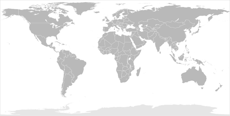
English: Blank political map of the world in modified (flattened) Robinson projection. This image is a sample of output from nugsl-worldmap, a Python script for the manipulation of this map. The script can also produce rotated images, add pinpoint marks at particular geographic coordinates, and produce web pages with clickable areas for specific countries and pinpoint marks.
Note that this map is not equirectangular, and cannot be used as a push-pin map to identify coordinates assuming equal latitude and longitude spacing. A map using the equirectangular projection is available at File:BlankMap-World6-Equirectangular.svg. |
| Ji̍t-kî | (for the script only) |
| Chhut-chhù |
http://www.law.nagoya-u.ac.jp/en/appendix/software/worldmap/ Refactored from Image:BlankMap-World.svg, q.v. |
| Chok-chiá | Frank Bennett |
| 授權允准 (Bô siŏh-huòi sāi ciā ùng-giông) |
The map data manipulated by the script is in the public domain. The raw output of the script, including the file shown here, is also in the public domain. |
| 其他版本 |
Derivative works of this file:
|
| SVG開發 |
Siū-khoân
| 我,此作品的版權所有人,釋出此作品至公共領域。此授權條款在全世界均適用。 這可能在某些國家不合法,如果是的話: 我授予任何人有權利使用此作品於任何用途,除受法律約束外,不受任何限制。 |
Tóng-àn le̍k-sú
Chhi̍h ji̍t-kî/sî-kan, khoàⁿ hit sî-chūn--ê tóng-àn.
| Ji̍t-kî/Sî-kan | 細張圖 | 寸尺 | Iōng-chiá | Chù-kái | |
|---|---|---|---|---|---|
| hiān-chāi | 2014-nî 3-goe̍h 20-ji̍t (pài-sì) 10:44 | | 2,754 × 1,397(1.68 MB) | Underlying lk | fix classes for Soudan and South Soudan |
| 2013-nî 3-goe̍h 16-ji̍t (pài-la̍k) 16:01 |  | 2,754 × 1,397(1.68 MB) | Flappiefh | South Sudan added. | |
| 2008-nî 1-goe̍h 14-ji̍t (pài-it) 11:47 |  | 2,754 × 1,397(1.67 MB) | Biercenator | Updated to current version of map produced by the script. | |
| 2007-nî 12-goe̍h 19-ji̍t (pài-saⁿ) 13:22 |  | 940 × 477(1.99 MB) | Biercenator | == Summary == Refactored from en:Image:BlankMap-World6.svg, q.v. This image is a sample of output from [http://gsl-nagoya-u.net/appendix/software/worldmap/ nugsl-worldmap], a Python script for the manipulation and maintenance of this map. The flatt | |
| 2007-nî 12-goe̍h 15-ji̍t (pài-la̍k) 15:31 |  | 940 × 477(2 MB) | Biercenator | Refactored from en:Image:BlankMap-World6.svg, q.v. This image might prove useful if you want to change the area shown in the center of the Robinson projection version, since the conversion can be reversed. | |
| 2007-nî 12-goe̍h 15-ji̍t (pài-la̍k) 15:18 |  | 940 × 477(2 MB) | Biercenator | == Summary == Refactored from en:BlankMap-World6.svg, q.v. This image might prove useful if you want to area shown in the center of the Robinson projection version, since the conversion can be reversed. |
Iáⁿ-siōng liân-kiat
Bô poàⁿ ia̍h liân kàu chit tiuⁿ iáⁿ-siōng.
tóng-àn hō͘ lâng sái--ê chōng-hóng
Ē-kha--ê kî-thaⁿ wiki ēng tio̍h chit--ê tóng-àn:
- ca.wikipedia.org hō͘ lâng ēng--ê chêng-hêng
- de.wikipedia.org hō͘ lâng ēng--ê chêng-hêng
- en.wikipedia.org hō͘ lâng ēng--ê chêng-hêng
- es.wikipedia.org hō͘ lâng ēng--ê chêng-hêng
- fr.wikipedia.org hō͘ lâng ēng--ê chêng-hêng
- he.wikipedia.org hō͘ lâng ēng--ê chêng-hêng