tóng-àn:Continental West Germanic languages.png

Seng khoàⁿ chiàm-liōng: 462 × 600 siōng-sò͘. Kî-thaⁿ--ê kái-sek-tō͘: 185 × 240 siōng-sò͘ | 370 × 480 siōng-sò͘ | 591 × 768 siōng-sò͘ | 789 × 1,024 siōng-sò͘ | 1,796 × 2,332 siōng-sò͘.
Choân kái-sek-tō͘ (1,796 × 2,332 siōng-sò͘ , tóng-àn chiàm-liōng: 539 KB, MIME luī-hêng: image/png)
|
|
Che sī tùi Wikimedia Commons ín--lâi ê chi̍t hūn tóng-àn. I tī hia ê kì-su̍t-ia̍h téng-bīn ê chu-sìn hián-sī ùi ē-té. |

|
這張圖片需要更新,因為:"complety" to "completely"在這樣做的時候,您可以為該圖片加入時間戳。
|


|
本圖片是以PNG、GIF或JPEG格式上傳。然而,其中包含的資料或訊息,應該重新建立成可縮放向量圖形(SVG)檔案,以更有效率或更準確的方式儲存。如有可能,請上傳本圖片的SVG格式版本。在上傳之後,請修改維基各姊妹計畫中所有使用舊版圖片的條目(列在圖像連結章節中),替換為新版圖片,並在舊圖片的描述頁中加入{{Vector version available|新圖片名稱.svg}}模板,同時移除本模板。
|
| Soat-bêng |
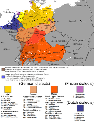
English: The dialectal ranges (not those of standard languages!) of the Continental West Germanic languages (Dutch/Frisian/German) after 1945 |
||
| Chhut-chhù |
|
||
| Chok-chiá | Rex Germanus | ||
| 授權允准 (Bô siŏh-huòi sāi ciā ùng-giông) |
|

Tóng-àn le̍k-sú
Chhi̍h ji̍t-kî/sî-kan, khoàⁿ hit sî-chūn--ê tóng-àn.
| Ji̍t-kî/Sî-kan | 細張圖 | 寸尺 | Iōng-chiá | Chù-kái | |
|---|---|---|---|---|---|
| hiān-chāi | 2023-nî 9-goe̍h 25-ji̍t (pài-it) 23:04 | | 1,796 × 2,332(539 KB) | Гинц фон Гинценфельд | In dieser Version ist die Westfälische Linie genauer markiert. |
| 2023-nî 9-goe̍h 25-ji̍t (pài-it) 22:52 |  | 1,796 × 2,332(538 KB) | Гинц фон Гинценфельд | In dieser Version ist die Westfälische Linie genauer markiert. | |
| 2023-nî 9-goe̍h 25-ji̍t (pài-it) 11:26 |  | 1,796 × 2,332(535 KB) | Гинц фон Гинценфельд | In dieser Version ist die Westfälische Linie genauer markiert. | |
| 2017-nî 8-goe̍h 8-ji̍t (pài-jī) 20:01 |  | 898 × 1,166(166 KB) | E-960 | Corrected location of city markers | |
| 2017-nî 5-goe̍h 6-ji̍t (pài-la̍k) 09:19 |  | 898 × 1,166(166 KB) | E-960 | Updated map to focus on Germany and the Benelux, also removed out of date areas, due to migration back to Germany after the fall of the Iron Curtain. | |
| 2017-nî 2-goe̍h 4-ji̍t (pài-la̍k) 17:49 |  | 1,028 × 1,196(193 KB) | E-960 | Added place name of Wien, and Český Krumlov in local language. | |
| 2017-nî 2-goe̍h 4-ji̍t (pài-la̍k) 17:11 |  | 1,028 × 1,196(193 KB) | E-960 | Adjusted place names reverting them to the local language of each individual country, also fixed the border between Belarus and Ukraine, and areas of German minority in Central and Eastern Europe. | |
| 2016-nî 8-goe̍h 12-ji̍t (pài-gō·) 17:07 |  | 1,028 × 1,196(154 KB) | Kontrollstellekundl | corr: Salzbaurg -> Salzburg Krummau -> Krumau Luxemburgish -> Luxembourgish Upper Sacon -> Upper Saxon + placement of various names | |
| 2014-nî 7-goe̍h 28-ji̍t (pài-it) 12:15 |  | 1,028 × 1,196(107 KB) | Crom daba | Shaded sub-dialect groupings a bit different so that they can be differentiated at a glance | |
| 2010-nî 9-goe̍h 4-ji̍t (pài-la̍k) 21:57 |  | 1,028 × 1,196(132 KB) | Hans Erren | Geographic border corrections (Borkum, Markerwaard) Western ripuarian border corrected |
Iáⁿ-siōng liân-kiat
Í-hā ê ia̍h liân kàu chit ê iáⁿ-siōng:
tóng-àn hō͘ lâng sái--ê chōng-hóng
Ē-kha--ê kî-thaⁿ wiki ēng tio̍h chit--ê tóng-àn:
- ace.wikipedia.org hō͘ lâng ēng--ê chêng-hêng
- af.wikipedia.org hō͘ lâng ēng--ê chêng-hêng
- azb.wikipedia.org hō͘ lâng ēng--ê chêng-hêng
- be-tarask.wikipedia.org hō͘ lâng ēng--ê chêng-hêng
- bg.wikipedia.org hō͘ lâng ēng--ê chêng-hêng
- ce.wikipedia.org hō͘ lâng ēng--ê chêng-hêng
- da.wikipedia.org hō͘ lâng ēng--ê chêng-hêng
- de.wikipedia.org hō͘ lâng ēng--ê chêng-hêng
- en.wikipedia.org hō͘ lâng ēng--ê chêng-hêng
- en.wikivoyage.org hō͘ lâng ēng--ê chêng-hêng
- es.wikipedia.org hō͘ lâng ēng--ê chêng-hêng
- fa.wikipedia.org hō͘ lâng ēng--ê chêng-hêng
- fr.wikipedia.org hō͘ lâng ēng--ê chêng-hêng
- ga.wikipedia.org hō͘ lâng ēng--ê chêng-hêng
- hr.wiktionary.org hō͘ lâng ēng--ê chêng-hêng
- id.wikipedia.org hō͘ lâng ēng--ê chêng-hêng
- ja.wikipedia.org hō͘ lâng ēng--ê chêng-hêng
- lij.wikipedia.org hō͘ lâng ēng--ê chêng-hêng
- mk.wikipedia.org hō͘ lâng ēng--ê chêng-hêng
- mn.wikipedia.org hō͘ lâng ēng--ê chêng-hêng
- pnb.wikipedia.org hō͘ lâng ēng--ê chêng-hêng
- ro.wikipedia.org hō͘ lâng ēng--ê chêng-hêng
- ru.wikipedia.org hō͘ lâng ēng--ê chêng-hêng
- simple.wikipedia.org hō͘ lâng ēng--ê chêng-hêng
- sl.wikipedia.org hō͘ lâng ēng--ê chêng-hêng
- sr.wikipedia.org hō͘ lâng ēng--ê chêng-hêng
- sv.wikipedia.org hō͘ lâng ēng--ê chêng-hêng
- uk.wikipedia.org hō͘ lâng ēng--ê chêng-hêng