tóng-àn:EXTERIOR VIEW, FRONT ELEVATION - Corry Homestead, Corry House, State Route 69, 10 miles South of Jasper (244 School Street), Oakman, Walker County, AL HABS ALA,64-OAK,A-1.tif

此 TIF 檔案的 JPG 預覽的大小:800 × 584 siōng-sò͘。 Kî-thaⁿ--ê kái-sek-tō͘: 320 × 234 siōng-sò͘ | 640 × 468 siōng-sò͘ | 1,024 × 748 siōng-sò͘ | 1,280 × 935 siōng-sò͘ | 2,560 × 1,870 siōng-sò͘ | 5,000 × 3,653 siōng-sò͘.
Choân kái-sek-tō͘ (5,000 × 3,653 siōng-sò͘ , tóng-àn chiàm-liōng: 17.42 MB, MIME luī-hêng: image/tiff)
|
|
Che sī tùi Wikimedia Commons ín--lâi ê chi̍t hūn tóng-àn. I tī hia ê kì-su̍t-ia̍h téng-bīn ê chu-sìn hián-sī ùi ē-té. |
Khài-iàu
| EXTERIOR VIEW, FRONT ELEVATION - Corry Homestead, Corry House, State Route 69, 10 miles South of Jasper (244 School Street), Oakman, Walker County, AL | ||||
|---|---|---|---|---|
| 攝影師 |
Related names:
|
|||
| 標題 |
EXTERIOR VIEW, FRONT ELEVATION - Corry Homestead, Corry House, State Route 69, 10 miles South of Jasper (244 School Street), Oakman, Walker County, AL |
|||
| 描繪地點 | Alabama; Walker County; Oakman | |||
| Ji̍t-kî | Documentation compiled after 1933 | |||
| 尺寸 | 8 x 10 in. | |||
| 目前所在位置 |
Library of Congress Prints and Photographs Division Washington, D.C. 20540 USA http://hdl.loc.gov/loc.pnp/pp.print |
|||
| 登錄號 |
HABS ALA,64-OAK,A-1 |
|||
| 取得方式/備註 |
|
|||
| 備註 |
|
|||
| Chhut-chhù | https://www.loc.gov/pictures/item/al1160.photos.046569p | |||
| 授權允准 (Bô siŏh-huòi sāi ciā ùng-giông) |
|
|||

| 目標地點 | | 位於此地的本圖片與其他圖片: OpenStreetMap |
|---|
Tóng-àn le̍k-sú
Chhi̍h ji̍t-kî/sî-kan, khoàⁿ hit sî-chūn--ê tóng-àn.
| Ji̍t-kî/Sî-kan | 細張圖 | 寸尺 | Iōng-chiá | Chù-kái | |
|---|---|---|---|---|---|
| hiān-chāi | 2014-nî 7-goe̍h 1-ji̍t (pài-jī) 03:08 | 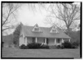 | 5,000 × 3,653(17.42 MB) | Fæ | GWToolset: Creating mediafile for Fæ. HABS batch upload 29 June 2014 (101:150) |
Iáⁿ-siōng liân-kiat
Í-hā ê ia̍h liân kàu chit ê iáⁿ-siōng:
tóng-àn hō͘ lâng sái--ê chōng-hóng
Ē-kha--ê kî-thaⁿ wiki ēng tio̍h chit--ê tóng-àn:
- ar.wikipedia.org hō͘ lâng ēng--ê chêng-hêng
- arz.wikipedia.org hō͘ lâng ēng--ê chêng-hêng
- ca.wikipedia.org hō͘ lâng ēng--ê chêng-hêng
- ceb.wikipedia.org hō͘ lâng ēng--ê chêng-hêng
- ce.wikipedia.org hō͘ lâng ēng--ê chêng-hêng
- cy.wikipedia.org hō͘ lâng ēng--ê chêng-hêng
- es.wikipedia.org hō͘ lâng ēng--ê chêng-hêng
- eu.wikipedia.org hō͘ lâng ēng--ê chêng-hêng
- fr.wikipedia.org hō͘ lâng ēng--ê chêng-hêng
- ht.wikipedia.org hō͘ lâng ēng--ê chêng-hêng
- it.wikipedia.org hō͘ lâng ēng--ê chêng-hêng
- lld.wikipedia.org hō͘ lâng ēng--ê chêng-hêng
- no.wikipedia.org hō͘ lâng ēng--ê chêng-hêng
- pl.wikipedia.org hō͘ lâng ēng--ê chêng-hêng
- pt.wikipedia.org hō͘ lâng ēng--ê chêng-hêng
- sr.wikipedia.org hō͘ lâng ēng--ê chêng-hêng
- tt.wikipedia.org hō͘ lâng ēng--ê chêng-hêng
- uk.wikipedia.org hō͘ lâng ēng--ê chêng-hêng
- uz.wikipedia.org hō͘ lâng ēng--ê chêng-hêng
- vi.wikipedia.org hō͘ lâng ēng--ê chêng-hêng
- www.wikidata.org hō͘ lâng ēng--ê chêng-hêng