tóng-àn:Lizars Mexico & Guatimala 1836 UTA (detail of Texas).jpg
Seng khoàⁿ chiàm-liōng: 694 × 600 siōng-sò͘. Kî-thaⁿ--ê kái-sek-tō͘: 278 × 240 siōng-sò͘ | 555 × 480 siōng-sò͘ | 889 × 768 siōng-sò͘ | 1,185 × 1,024 siōng-sò͘ | 1,357 × 1,173 siōng-sò͘.
Choân kái-sek-tō͘ (1,357 × 1,173 siōng-sò͘ , tóng-àn chiàm-liōng: 983 KB, MIME luī-hêng: image/jpeg)
|
|
Che sī tùi Wikimedia Commons ín--lâi ê chi̍t hūn tóng-àn. I tī hia ê kì-su̍t-ia̍h téng-bīn ê chu-sìn hián-sī ùi ē-té. |
Khài-iàu
| 標題 |
English: Mexico & Guatimala [sic] |
|||||||||||||||||||
| 描寫 |
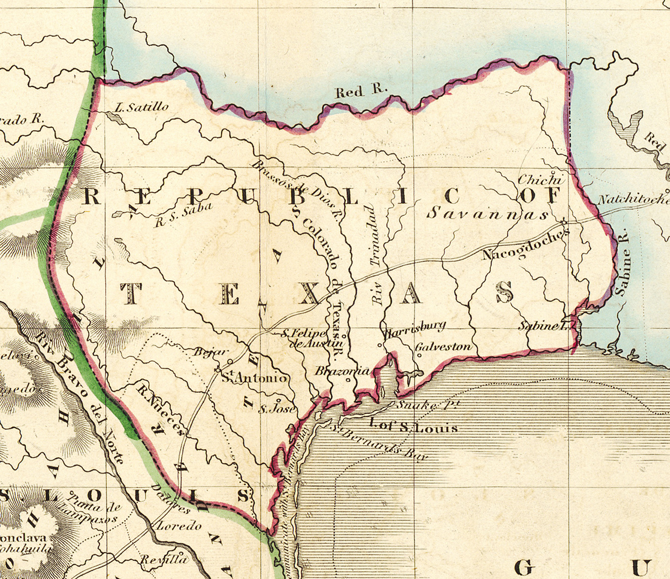
English: Shortly after Texas declared its independence from Mexico in 1836, the Edinburgh painter, engraver, printer, cartographer, lithographer, and publisher William Home Lizars (1788-1859), brother of Daniel Lizars II (1793-1875), updated the original plate for the map of Mexico & Guatemala to include the new republic. He added the towns of Galveston, Harrisburg, Brazoria, S. Felipe de Austin (although recently destroyed), Bejar, and "S. Jose" (probably intended to represent Goliad). Lizars made no further improvements to the general cartographic shape of the republic except to show the Nueces River as the southern boundary and the western boundary curving to the point where the 100th meridian strikes the Red River. The map continues to show Mexico's administrative districts as Spanish Intendencies (Intendencias) and Internal Provinces (Provincias Internas) over fifteen years since Mexico's independence. |
|||||||||||||||||||
| Ji̍t-kî | 約1836年 | |||||||||||||||||||
| Chhut-chhù | UTA Libraries Cartographic Connections: 地圖 / text | |||||||||||||||||||
| 創作作者 |
|
|||||||||||||||||||
| 取得方式/備註 |
English: The University of Texas at Arlington Libraries Special Collections, Gift of Lewis & Virginia Buttery |
|||||||||||||||||||
| Geotemporal data | ||||||||||||||||||||
| 地圖位置 | Texas | |||||||||||||||||||
| 地理參考 | 如果不合適,請設定「warp_status = skip」為隱藏。 | |||||||||||||||||||
| Bibliographic data | ||||||||||||||||||||
| 出版地 | Edinburgh | |||||||||||||||||||
| 出版商 |
|
|||||||||||||||||||
| Archival data | ||||||||||||||||||||
| 館藏 | ||||||||||||||||||||
| 尺寸 | 高度: 42厘米; 寬度: 51.5厘米 | |||||||||||||||||||
| 表現方法 | colored engraving on paper | |||||||||||||||||||
| artwork-references |
Worms, Laurence; Ashley Baynton-Williams (2011年) 《 British Map Engravers》, Lûn-tun: Rare Book Society, pp. 406–409 |
|||||||||||||||||||
| 其他版本 | ||||||||||||||||||||

.jpg)
Siū-khoân

|
This file was provided to Wikimedia Commons by the University of Texas at Arlington Libraries as part of a cooperation project. The University of Texas at Arlington Libraries is part of the University of Texas at Arlington, a public research university located in Arlington, Texas.
|
|
本作品作者於1859年逝世,在其來源國以及其他著作權期限是作者逝世後100年或以下的國家與地區屬於公有領域。 | |
| 此作品無已知的著作權限制,亦不受所有相關和鄰接的權利限制。 | |
Tóng-àn le̍k-sú
Chhi̍h ji̍t-kî/sî-kan, khoàⁿ hit sî-chūn--ê tóng-àn.
| Ji̍t-kî/Sî-kan | 細張圖 | 寸尺 | Iōng-chiá | Chù-kái | |
|---|---|---|---|---|---|
| hiān-chāi | 2019-nî 7-goe̍h 13-ji̍t (pài-la̍k) 15:18 | | 1,357 × 1,173(983 KB) | Michael Barera | File:Lizars Mexico & Guatimala 1836 UTA.jpg cropped 79 % horizontally, 78 % vertically using CropTool with precise mode. |
Iáⁿ-siōng liân-kiat
Í-hā ê ia̍h liân kàu chit ê iáⁿ-siōng:
tóng-àn hō͘ lâng sái--ê chōng-hóng
Ē-kha--ê kî-thaⁿ wiki ēng tio̍h chit--ê tóng-àn:
- azb.wikipedia.org hō͘ lâng ēng--ê chêng-hêng
- ca.wikipedia.org hō͘ lâng ēng--ê chêng-hêng
- cv.wikipedia.org hō͘ lâng ēng--ê chêng-hêng
- en.wikipedia.org hō͘ lâng ēng--ê chêng-hêng
- eo.wikipedia.org hō͘ lâng ēng--ê chêng-hêng
- fa.wikipedia.org hō͘ lâng ēng--ê chêng-hêng
- it.wikipedia.org hō͘ lâng ēng--ê chêng-hêng
- ja.wikipedia.org hō͘ lâng ēng--ê chêng-hêng
- ko.wikipedia.org hō͘ lâng ēng--ê chêng-hêng
- mk.wikipedia.org hō͘ lâng ēng--ê chêng-hêng
- mzn.wikipedia.org hō͘ lâng ēng--ê chêng-hêng
- pl.wikipedia.org hō͘ lâng ēng--ê chêng-hêng
- pt.wikipedia.org hō͘ lâng ēng--ê chêng-hêng
- sv.wikipedia.org hō͘ lâng ēng--ê chêng-hêng
- th.wikipedia.org hō͘ lâng ēng--ê chêng-hêng
- yi.wikipedia.org hō͘ lâng ēng--ê chêng-hêng
.jpg)