tóng-àn:Map of South Africa with Tshwane highlighted (2011).svg

此 SVG 檔案的 PNG 預覽的大小:684 × 599 siōng-sò͘。 Kî-thaⁿ--ê kái-sek-tō͘: 274 × 240 siōng-sò͘ | 548 × 480 siōng-sò͘ | 876 × 768 siōng-sò͘ | 1,168 × 1,024 siōng-sò͘ | 2,337 × 2,048 siōng-sò͘ | 809 × 709 siōng-sò͘.
Choân kái-sek-tō͘ (SVG ùng-giông, chék-cháung: 809 × 709 chuông-só, ùng-giông duâi-nâung:467 KB)
|
|
Che sī tùi Wikimedia Commons ín--lâi ê chi̍t hūn tóng-àn. I tī hia ê kì-su̍t-ia̍h téng-bīn ê chu-sìn hián-sī ùi ē-té. |
.svg)
Khài-iàu
| Soat-bêng |
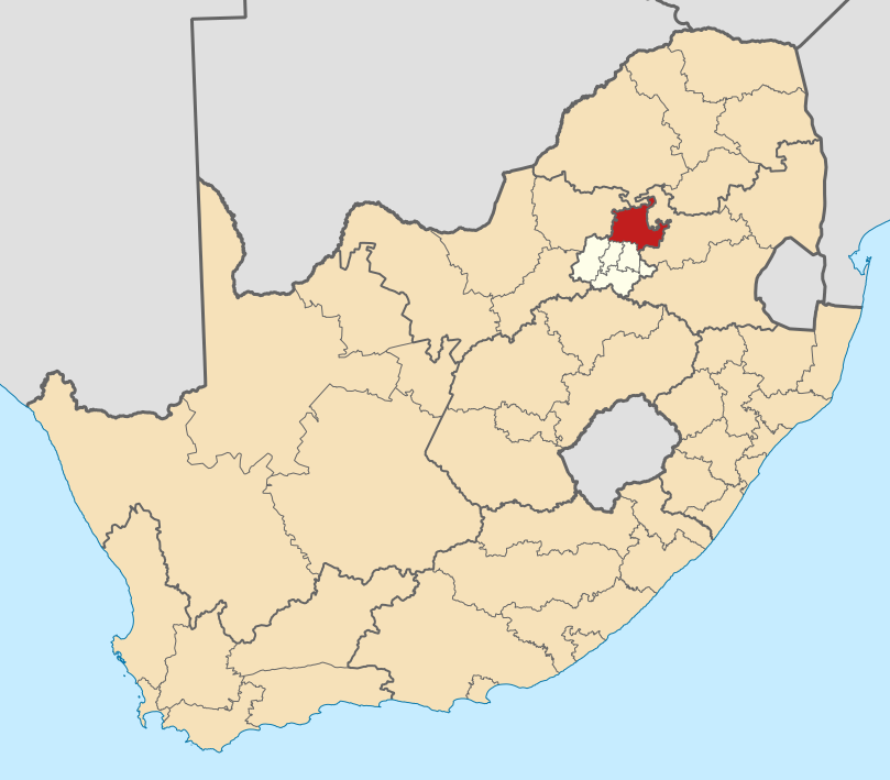
English: Map of district boundaries in South Africa, as they will be after the municipal elections of 18 May 2011, with the City of Tshwane Metropolitan Municipality highlighted in red within Gauteng in yellow. |
| Ji̍t-kî | |
| Chhut-chhù | Ka-tī chò--ê |
| Chok-chiá | Htonl |
Siū-khoân
我,本作品的著作權持有者,決定用以下授權條款發佈本作品:

|
已授權您依據自由軟體基金會發行的無固定段落、封面文字和封底文字GNU自由文件授權條款1.2版或任意後續版本,對本檔進行複製、傳播和/或修改。該協議的副本列在GNU自由文件授權條款中。 |
This file is licensed under the Creative Commons Attribution-Share Alike 4.0 International, 3.0 Unported, 2.5 Generic, 2.0 Generic and 1.0 Generic license.
- 你會使自由:
- 分享 – kho͘-pih, hoat-pò͘ kap thoân-pò͘ pún chok
- 重新修改 – kái-pian pún chok-phín
- Àn i-hā ê tiâu-kiāⁿ
- 標示名姓 – 您必須指名出正確的製作者,和提供授權條款的連結,以及表示是否有對內容上做出變更。您可以用任何合理的方式來行動,但不得以任何方式表明授權條款是對您許可或是由您所使用。
- 仝款方式方享 – Lí nā kái-tōng, piàn-khoán, he̍k-chiá kun-kù pún chok chhòng-chō, lí kaⁿ-taⁿ ē-tàng ēng kap pún chok kâng-khoán he̍k-chiá saⁿ-chhiūⁿ ê hí-khó lâi hoat-pò͘ chò--chhut-lâi ê chok-phín.
Nṳ̄ buóh dĭk sié-nó̤h sêu-guòng dèu-kuāng dŭ kō̤-ī gēng.
Tóng-àn le̍k-sú
Chhi̍h ji̍t-kî/sî-kan, khoàⁿ hit sî-chūn--ê tóng-àn.
| Ji̍t-kî/Sî-kan | 細張圖 | 寸尺 | Iōng-chiá | Chù-kái | |
|---|---|---|---|---|---|
| hiān-chāi | 2011-nî 5-goe̍h 2-ji̍t (pài-it) 20:19 | | 809 × 709(467 KB) | Htonl | == Summary == {{Information |Description ={{en|1=Map of district boundaries in South Africa, as they will be after the municipal elections of 18 May 2011, with the [[w:City of Tshwane Metropolitan Municipali |
Iáⁿ-siōng liân-kiat
Í-hā ê ia̍h liân kàu chit ê iáⁿ-siōng:
tóng-àn hō͘ lâng sái--ê chōng-hóng
Ē-kha--ê kî-thaⁿ wiki ēng tio̍h chit--ê tóng-àn:
- af.wikipedia.org hō͘ lâng ēng--ê chêng-hêng
- Pretoria
- Centurion
- Cullinan
- Marabastad
- Brooklyn, Pretoria
- Waterkloof
- Groenkloof
- Hatfield, Pretoria
- Arcadia, Pretoria
- Elarduspark
- Irene
- Bronkhorstspruit
- Valhalla
- Kleinfontein
- Mabopane
- Atteridgeville
- Capital Park
- Hammanskraal
- Rayton
- Die Wilgers
- Winterveld
- Rietfontein, Pretoria
- Highveld
- Erasmuskloof
- Wingate Park
- Pierre van Ryneveldpark
- Moreletapark
- Monument Park
- Waterkloofrif
- Menlopark, Pretoria
- Kloofsig
- Lyttelton
- Constantiapark
- Lynnwood
- Olievenhoutbosch
- Ga-Rankuwa
- Mamelodi
- Soshanguve
- Akasia
- Temba
- Chantelle
- Orchards, Pretoria
- Pretoria-Noord
- Rosslyn
- Laudium
- Lyttelton Manor
- Doringkloof
- Villieria
- Waverley
- Garsfontein
檢視此檔案的更多全域使用狀況。
.svg)
.svg)