tóng-àn:Maricopa County Incorporated and Planning areas Gila Bend highlighted.svg

此 SVG 檔案的 PNG 預覽的大小:694 × 599 siōng-sò͘。 Kî-thaⁿ--ê kái-sek-tō͘: 278 × 240 siōng-sò͘ | 556 × 480 siōng-sò͘ | 889 × 768 siōng-sò͘ | 1,185 × 1,024 siōng-sò͘ | 2,371 × 2,048 siōng-sò͘ | 940 × 812 siōng-sò͘.
Choân kái-sek-tō͘ (SVG ùng-giông, chék-cháung: 940 × 812 chuông-só, ùng-giông duâi-nâung:1.05 MB)
|
|
Che sī tùi Wikimedia Commons ín--lâi ê chi̍t hūn tóng-àn. I tī hia ê kì-su̍t-ia̍h téng-bīn ê chu-sìn hián-sī ùi ē-té. |
Khài-iàu
| Soat-bêng |
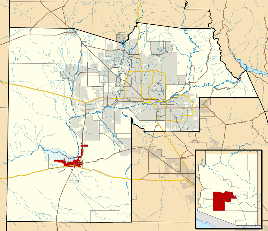
This map shows the incorporated areas and Indian reservation boundaries in Maricopa County, Arizona, along with water bodies and major highways and roads.
|
| Ji̍t-kî | |
| Chhut-chhù | My own work, based on government information |
| Chok-chiá | Ixnayonthetimmay |
| 授權允准 (Bô siŏh-huòi sāi ciā ùng-giông) |
Public Domain |
| 其他版本 | See Category:Maps of Maricopa County for other versions of this image. |
Siū-khoân
| 我,此作品的版權所有人,釋出此作品至公共領域。此授權條款在全世界均適用。 這可能在某些國家不合法,如果是的話: 我授予任何人有權利使用此作品於任何用途,除受法律約束外,不受任何限制。 |
Tóng-àn le̍k-sú
Chhi̍h ji̍t-kî/sî-kan, khoàⁿ hit sî-chūn--ê tóng-àn.
| Ji̍t-kî/Sî-kan | 細張圖 | 寸尺 | Iōng-chiá | Chù-kái | |
|---|---|---|---|---|---|
| hiān-chāi | 2011-nî 5-goe̍h 20-ji̍t (pài-gō·) 06:28 | | 940 × 812(1.05 MB) | Ixnayonthetimmay | Uploading new version |
| 2008-nî 8-goe̍h 30-ji̍t (pài-la̍k) 04:08 |  | 900 × 800(413 KB) | Ixnayonthetimmay | == Summary == {{Information |Description=This map shows the incorporated areas and unincorporated areas in Maricopa County, Arizona. [[:en:Gila Bend, Arizona | |
| 2007-nî 9-goe̍h 16-ji̍t (lé-pài) 00:26 |  | 900 × 800(384 KB) | Ixnayonthetimmay | == Summary == {{Information |Description=This map shows the incorporated areas in Maricopa County, Arizona. It also shows the boundaries for the municipal planning areas. [[:en:Gila Ben | |
| 2007-nî 5-goe̍h 28-ji̍t (pài-it) 09:58 |  | 900 × 780(329 KB) | Ixnayonthetimmay | ||
| 2007-nî 5-goe̍h 22-ji̍t (pài-jī) 00:05 |  | 900 × 780(318 KB) | Ixnayonthetimmay | ||
| 2007-nî 1-goe̍h 30-ji̍t (pài-jī) 05:03 |  | 904 × 758(189 KB) | Ixnayonthetimmay | {{Information |Description=This map shows the incorporated areas in Maricopa County, Arizona, highlighting Gila Bend in red. It also shows the boundaries for th |
Iáⁿ-siōng liân-kiat
Í-hā ê ia̍h liân kàu chit ê iáⁿ-siōng:
tóng-àn hō͘ lâng sái--ê chōng-hóng
Ē-kha--ê kî-thaⁿ wiki ēng tio̍h chit--ê tóng-àn:
- ar.wikipedia.org hō͘ lâng ēng--ê chêng-hêng
- ca.wikipedia.org hō͘ lâng ēng--ê chêng-hêng
- cy.wikipedia.org hō͘ lâng ēng--ê chêng-hêng
- de.wikipedia.org hō͘ lâng ēng--ê chêng-hêng
- eu.wikipedia.org hō͘ lâng ēng--ê chêng-hêng
- fa.wikipedia.org hō͘ lâng ēng--ê chêng-hêng
- fr.wikipedia.org hō͘ lâng ēng--ê chêng-hêng
- ht.wikipedia.org hō͘ lâng ēng--ê chêng-hêng
- it.wikipedia.org hō͘ lâng ēng--ê chêng-hêng
- pt.wikipedia.org hō͘ lâng ēng--ê chêng-hêng
- sr.wikipedia.org hō͘ lâng ēng--ê chêng-hêng
- tt.wikipedia.org hō͘ lâng ēng--ê chêng-hêng
- www.wikidata.org hō͘ lâng ēng--ê chêng-hêng