tóng-àn:Perspective view of truss span, looking NE. - Pennsylvania Railroad, West Brownsville Junction Bridge, Spanning Monongahela River, north of U.S. Route 40 Bridge, West Brownsville, HAER PA,63-BROVW,1-2.tif

此 TIF 檔案的 JPG 預覽的大小:800 × 571 siōng-sò͘。 Kî-thaⁿ--ê kái-sek-tō͘: 320 × 228 siōng-sò͘ | 640 × 457 siōng-sò͘ | 1,024 × 731 siōng-sò͘ | 1,280 × 914 siōng-sò͘ | 2,560 × 1,827 siōng-sò͘ | 5,000 × 3,569 siōng-sò͘.
Choân kái-sek-tō͘ (5,000 × 3,569 siōng-sò͘ , tóng-àn chiàm-liōng: 17.02 MB, MIME luī-hêng: image/tiff)
|
|
Che sī tùi Wikimedia Commons ín--lâi ê chi̍t hūn tóng-àn. I tī hia ê kì-su̍t-ia̍h téng-bīn ê chu-sìn hián-sī ùi ē-té. |
| Perspective view of truss span, looking NE. - Pennsylvania Railroad, West Brownsville Junction Bridge, Spanning Monongahela River, north of U.S. Route 40 Bridge, West Brownsville, Washington County, PA | ||||
|---|---|---|---|---|
| 攝影師 |
Lowe, Jet, creator |
|||
| 標題 |
Perspective view of truss span, looking NE. - Pennsylvania Railroad, West Brownsville Junction Bridge, Spanning Monongahela River, north of U.S. Route 40 Bridge, West Brownsville, Washington County, PA |
|||
| Soat-bêng |
Leonard, H R; Pennsylvania Steel Company; Lucius Engineering Company; Pennsylvania Railroad; Consolidated Rail Corporation (Conrail); Norfolk Southern Railroad; DeLony, Eric N, project manager; Pennsylvania Historical and Museum Commission, sponsor; Consolidated Rail Corporation (Conrail), sponsor; Spivey, Justin M, historian; Lowe, Jet, photographer |
|||
| 描繪地點 | Pennsylvania; Washington County; West Brownsville | |||
| Ji̍t-kî | 1999年 | |||
| 尺寸 | 5 x 7 in. | |||
| 目前所在位置 |
Library of Congress Prints and Photographs Division Washington, D.C. 20540 USA http://hdl.loc.gov/loc.pnp/pp.print |
|||
| 登錄號 |
HAER PA,63-BROVW,1-2 |
|||
| 取得方式/備註 |
|
|||
| 備註 |
|
|||
| Chhut-chhù | https://www.loc.gov/pictures/item/pa3769.photos.362296p | |||
| 授權允准 (Bô siŏh-huòi sāi ciā ùng-giông) |
|
|||

Tóng-àn le̍k-sú
Chhi̍h ji̍t-kî/sî-kan, khoàⁿ hit sî-chūn--ê tóng-àn.
| Ji̍t-kî/Sî-kan | 細張圖 | 寸尺 | Iōng-chiá | Chù-kái | |
|---|---|---|---|---|---|
| hiān-chāi | 2014-nî 8-goe̍h 1-ji̍t (pài-gō·) 05:59 | 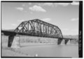 | 5,000 × 3,569(17.02 MB) | Fæ | GWToolset: Creating mediafile for Fæ. HABS 31 July 2014 (3000:3200) |
Iáⁿ-siōng liân-kiat
Í-hā ê ia̍h liân kàu chit ê iáⁿ-siōng:
tóng-àn hō͘ lâng sái--ê chōng-hóng
Ē-kha--ê kî-thaⁿ wiki ēng tio̍h chit--ê tóng-àn:
- ceb.wikipedia.org hō͘ lâng ēng--ê chêng-hêng
- ce.wikipedia.org hō͘ lâng ēng--ê chêng-hêng
- cy.wikipedia.org hō͘ lâng ēng--ê chêng-hêng
- en.wikipedia.org hō͘ lâng ēng--ê chêng-hêng
- es.wikipedia.org hō͘ lâng ēng--ê chêng-hêng
- eu.wikipedia.org hō͘ lâng ēng--ê chêng-hêng
- fr.wikipedia.org hō͘ lâng ēng--ê chêng-hêng
- ht.wikipedia.org hō͘ lâng ēng--ê chêng-hêng
- it.wikipedia.org hō͘ lâng ēng--ê chêng-hêng
- lld.wikipedia.org hō͘ lâng ēng--ê chêng-hêng
- pt.wikipedia.org hō͘ lâng ēng--ê chêng-hêng
- sr.wikipedia.org hō͘ lâng ēng--ê chêng-hêng
- tt.wikipedia.org hō͘ lâng ēng--ê chêng-hêng
- uk.wikipedia.org hō͘ lâng ēng--ê chêng-hêng
- uz.wikipedia.org hō͘ lâng ēng--ê chêng-hêng
- vi.wikipedia.org hō͘ lâng ēng--ê chêng-hêng
- www.wikidata.org hō͘ lâng ēng--ê chêng-hêng