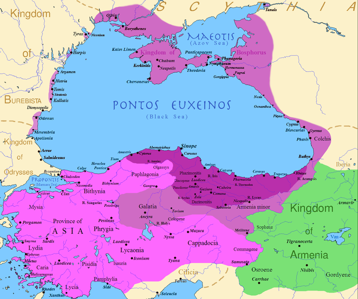
tóng-àn:PonticKingdom.png

Seng khoàⁿ chiàm-liōng: 718 × 600 siōng-sò͘. Kî-thaⁿ--ê kái-sek-tō͘: 287 × 240 siōng-sò͘ | 575 × 480 siōng-sò͘ | 919 × 768 siōng-sò͘ | 1,226 × 1,024 siōng-sò͘ | 1,551 × 1,296 siōng-sò͘.
Choân kái-sek-tō͘ (1,551 × 1,296 siōng-sò͘ , tóng-àn chiàm-liōng: 219 KB, MIME luī-hêng: image/png)
Tóng-àn le̍k-sú
Chhi̍h ji̍t-kî/sî-kan, khoàⁿ hit sî-chūn--ê tóng-àn.
| Ji̍t-kî/Sî-kan | Suè-tiunn-tôo | Tshùn-tshioh | Iōng-chiá | Chù-kái | |
|---|---|---|---|---|---|
| hiān-chāi | 2024-nî 11-goe̍h 15-ji̍t (pài-gō·) 13:20 |  | 1,551 × 1,296(219 KB) | GrandEscogriffe | location of Ancyra |
| 2017-nî 12-goe̍h 9-ji̍t (pài-la̍k) 02:00 |  | 1,551 × 1,296(265 KB) | SteinsplitterBot | Bot: Image rotated by 90° | |
| 2017-nî 12-goe̍h 9-ji̍t (pài-la̍k) 00:00 |  | 1,296 × 1,551(316 KB) | SteinsplitterBot | Bot: Image rotated by 270° | |
| 2016-nî 9-goe̍h 22-ji̍t (pài-sì) 17:54 |  | 1,551 × 1,296(265 KB) | Hohum | Lighten water area | |
| 2016-nî 8-goe̍h 9-ji̍t (pài-jī) 11:21 |  | 1,551 × 1,296(260 KB) | MAXHO | Details : more cities & shoreline of this time | |
| 2015-nî 10-goe̍h 1-ji̍t (pài-sì) 20:57 |  | 1,551 × 1,296(249 KB) | Spiridon Ion Cepleanu | Cosmetic again | |
| 2015-nî 9-goe̍h 30-ji̍t (pài-saⁿ) 12:55 |  | 1,551 × 1,296(247 KB) | Spiridon Ion Cepleanu | Cosmetic colours & background names | |
| 2014-nî 4-goe̍h 7-ji̍t (pài-it) 14:21 |  | 1,551 × 1,296(225 KB) | Spiridon Ion Cepleanu | Little changes (ancient shoreline & some greek colonies under Pontic rule) according with V. Yanko-Hombach, A.S. Gilbert, N. Panin, P. M. Dolukhanov: ''The Black Sea Flood Question: Changes in Coastline, Climate, and Human Settlement'', Springer, Nethe... | |
| 2009-nî 7-goe̍h 20-ji̍t (pài-it) 04:14 |  | 1,551 × 1,296(200 KB) | File Upload Bot (Magnus Manske) | {{BotMoveToCommons|en.wikipedia|year={{subst:CURRENTYEAR}}|month={{subst:CURRENTMONTHNAME}}|day={{subst:CURRENTDAY}}}} {{Information |Description={{en|Map of the Kingdom of Pontus, Before the reign of mithridates VI (darkest purple), after his conquests |
Iáⁿ-siōng liân-kiat
Í-hā ê ia̍h liân kàu chit ê iáⁿ-siōng:
tóng-àn hō͘ lâng sái--ê chōng-hóng
Ē-kha--ê kî-thaⁿ wiki ēng tio̍h chit--ê tóng-àn:
- ar.wikipedia.org hō͘ lâng ēng--ê chêng-hêng
- ast.wikipedia.org hō͘ lâng ēng--ê chêng-hêng
- azb.wikipedia.org hō͘ lâng ēng--ê chêng-hêng
- az.wikipedia.org hō͘ lâng ēng--ê chêng-hêng
- bg.wikipedia.org hō͘ lâng ēng--ê chêng-hêng
- br.wikipedia.org hō͘ lâng ēng--ê chêng-hêng
- ca.wikipedia.org hō͘ lâng ēng--ê chêng-hêng
- cs.wikipedia.org hō͘ lâng ēng--ê chêng-hêng
- da.wikipedia.org hō͘ lâng ēng--ê chêng-hêng
- de.wikipedia.org hō͘ lâng ēng--ê chêng-hêng
- el.wikipedia.org hō͘ lâng ēng--ê chêng-hêng
- en.wikipedia.org hō͘ lâng ēng--ê chêng-hêng
- es.wikipedia.org hō͘ lâng ēng--ê chêng-hêng
- et.wikipedia.org hō͘ lâng ēng--ê chêng-hêng
- eu.wikipedia.org hō͘ lâng ēng--ê chêng-hêng
- fa.wikipedia.org hō͘ lâng ēng--ê chêng-hêng
- fr.wikipedia.org hō͘ lâng ēng--ê chêng-hêng
Khuànn tsit-ê tóng-àn ê koh-khah-tsuē tsuân-i̍k sú-iōng.
