tóng-àn:Sharondale Road in Sharonville.jpg

Seng khoàⁿ chiàm-liōng: 800 × 600 siōng-sò͘. Kî-thaⁿ--ê kái-sek-tō͘: 320 × 240 siōng-sò͘ | 640 × 480 siōng-sò͘ | 1,024 × 768 siōng-sò͘ | 1,280 × 960 siōng-sò͘ | 2,272 × 1,704 siōng-sò͘.
Choân kái-sek-tō͘ (2,272 × 1,704 siōng-sò͘ , tóng-àn chiàm-liōng: 2.22 MB, MIME luī-hêng: image/jpeg)
|
|
Che sī tùi Wikimedia Commons ín--lâi ê chi̍t hūn tóng-àn. I tī hia ê kì-su̍t-ia̍h téng-bīn ê chu-sìn hián-sī ùi ē-té. |
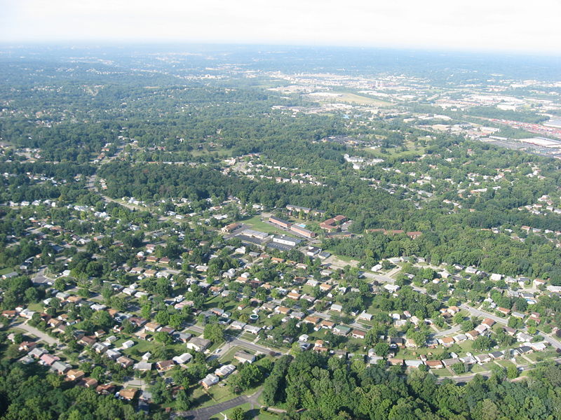
| Soat-bêng | Aerial view of southern Sharonville, a city primarily in Hamilton County, Ohio, United States; although part of the city extends into Butler County, this picture is taken exclusively over Hamilton County. The church and parking lot in the center of the picture are located along Sharondale Road just north of its intersection with Elljay Drive. Picture taken from a Diamond Eclipse light airplane at an altitude of 1,740 feet MSL and a bearing of approximately 232º. | ||
| Ji̍t-kî | 攝於2008年8-goe̍h12日 | ||
| Chhut-chhù | Ka-tī chò--ê | ||
| Chok-chiá | Nyttend | ||
| 授權允准 (Bô siŏh-huòi sāi ciā ùng-giông) |
|
Tóng-àn le̍k-sú
Chhi̍h ji̍t-kî/sî-kan, khoàⁿ hit sî-chūn--ê tóng-àn.
| Ji̍t-kî/Sî-kan | 細張圖 | 寸尺 | Iōng-chiá | Chù-kái | |
|---|---|---|---|---|---|
| hiān-chāi | 2008-nî 9-goe̍h 22-ji̍t (pài-it) 14:30 | | 2,272 × 1,704(2.22 MB) | Nyttend | {{Information |Description=Aerial view of southern {{w|Sharonville, Ohio|Sharonville}}, a city primarily in {{w|Hamilton County, Ohio|Hamilton County}}, {{w|Ohio}}, {{w|United States}}; although part of the city extends into {{w|Butler County, Ohio|Butler |
Iáⁿ-siōng liân-kiat
Í-hā ê ia̍h liân kàu chit ê iáⁿ-siōng:
tóng-àn hō͘ lâng sái--ê chōng-hóng
Ē-kha--ê kî-thaⁿ wiki ēng tio̍h chit--ê tóng-àn:
- ar.wikipedia.org hō͘ lâng ēng--ê chêng-hêng
- arz.wikipedia.org hō͘ lâng ēng--ê chêng-hêng
- bg.wikipedia.org hō͘ lâng ēng--ê chêng-hêng
- ca.wikipedia.org hō͘ lâng ēng--ê chêng-hêng
- ceb.wikipedia.org hō͘ lâng ēng--ê chêng-hêng
- ce.wikipedia.org hō͘ lâng ēng--ê chêng-hêng
- cy.wikipedia.org hō͘ lâng ēng--ê chêng-hêng
- de.wikipedia.org hō͘ lâng ēng--ê chêng-hêng
- en.wikivoyage.org hō͘ lâng ēng--ê chêng-hêng
- es.wikipedia.org hō͘ lâng ēng--ê chêng-hêng
- eu.wikipedia.org hō͘ lâng ēng--ê chêng-hêng
- fa.wikipedia.org hō͘ lâng ēng--ê chêng-hêng
- fr.wikipedia.org hō͘ lâng ēng--ê chêng-hêng
- ht.wikipedia.org hō͘ lâng ēng--ê chêng-hêng
- it.wikipedia.org hō͘ lâng ēng--ê chêng-hêng
- it.wikivoyage.org hō͘ lâng ēng--ê chêng-hêng
- ky.wikipedia.org hō͘ lâng ēng--ê chêng-hêng
- lld.wikipedia.org hō͘ lâng ēng--ê chêng-hêng
- pl.wikipedia.org hō͘ lâng ēng--ê chêng-hêng
- pt.wikipedia.org hō͘ lâng ēng--ê chêng-hêng
- sh.wikipedia.org hō͘ lâng ēng--ê chêng-hêng
- sr.wikipedia.org hō͘ lâng ēng--ê chêng-hêng
- sv.wikipedia.org hō͘ lâng ēng--ê chêng-hêng
- tr.wikipedia.org hō͘ lâng ēng--ê chêng-hêng
- tt.wikipedia.org hō͘ lâng ēng--ê chêng-hêng
- uz.wikipedia.org hō͘ lâng ēng--ê chêng-hêng
- vi.wikipedia.org hō͘ lâng ēng--ê chêng-hêng
- vo.wikipedia.org hō͘ lâng ēng--ê chêng-hêng
- www.wikidata.org hō͘ lâng ēng--ê chêng-hêng