tóng-àn:Sunda Strait map-fr.svg

此 SVG 檔案的 PNG 預覽的大小:800 × 535 siōng-sò͘。 Kî-thaⁿ--ê kái-sek-tō͘: 320 × 214 siōng-sò͘ | 640 × 428 siōng-sò͘ | 1,024 × 685 siōng-sò͘ | 1,280 × 857 siōng-sò͘ | 2,560 × 1,713 siōng-sò͘ | 3,579 × 2,395 siōng-sò͘.
Choân kái-sek-tō͘ (SVG ùng-giông, chék-cháung: 3,579 × 2,395 chuông-só, ùng-giông duâi-nâung:2.08 MB)
|
|
Che sī tùi Wikimedia Commons ín--lâi ê chi̍t hūn tóng-àn. I tī hia ê kì-su̍t-ia̍h téng-bīn ê chu-sìn hián-sī ùi ē-té. |
Khài-iàu
| Soat-bêng |
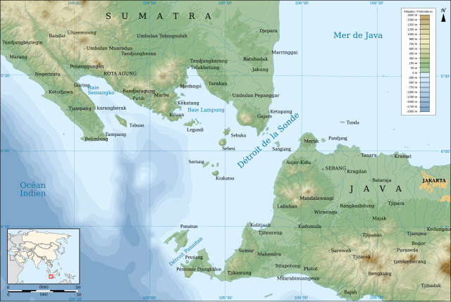
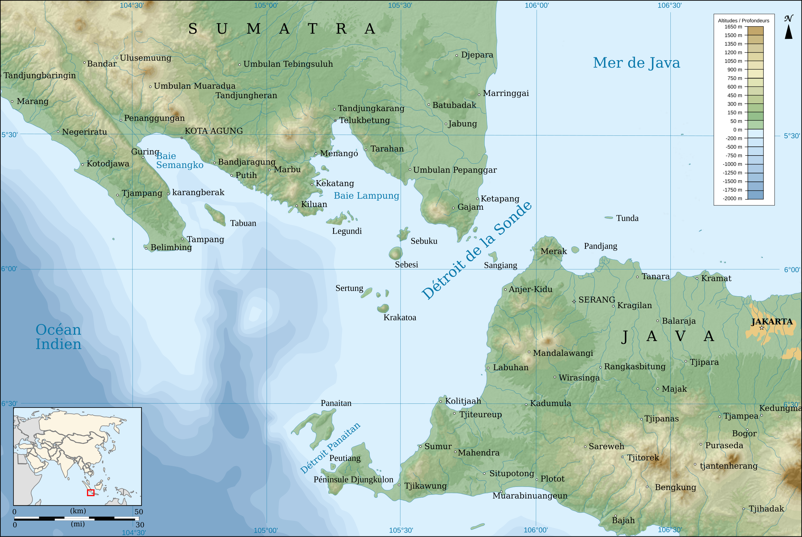
English: Map of the Sunda Strait, in french.
Français : Carte du Détroit de la Sonde, en français. |
||
| Ji̍t-kî | |||
| Chhut-chhù |
travail personnel. Source :
|
||
| Chok-chiá | Pinpin | ||
| 其他版本 | |||
| SVG | W3C-validity not checked.
|
||
| Graphic Lab |

| 拍攝地點 | | 位於此地的本圖片與其他圖片: OpenStreetMap |
|---|
Siū-khoân
我,本作品的著作權持有者,決定用以下授權條款發佈本作品:
| 公共版權:本藝術作品是自由的,您可以依據自由藝術作品許可協議的條款傳播和/或修改本藝術作品。您可以在Copyleft Attitude網站或其他網站找到該許可協議的樣本。 |
This file is licensed under the Creative Commons Attribution-Share Alike 4.0 International, 3.0 Unported, 2.5 Generic, 2.0 Generic and 1.0 Generic license.
- 你會使自由:
- 分享 – kho͘-pih, hoat-pò͘ kap thoân-pò͘ pún chok
- 重新修改 – kái-pian pún chok-phín
- Àn i-hā ê tiâu-kiāⁿ
- 標示名姓 – 您必須指名出正確的製作者,和提供授權條款的連結,以及表示是否有對內容上做出變更。您可以用任何合理的方式來行動,但不得以任何方式表明授權條款是對您許可或是由您所使用。
- 仝款方式方享 – Lí nā kái-tōng, piàn-khoán, he̍k-chiá kun-kù pún chok chhòng-chō, lí kaⁿ-taⁿ ē-tàng ēng kap pún chok kâng-khoán he̍k-chiá saⁿ-chhiūⁿ ê hí-khó lâi hoat-pò͘ chò--chhut-lâi ê chok-phín.
Nṳ̄ buóh dĭk sié-nó̤h sêu-guòng dèu-kuāng dŭ kō̤-ī gēng.
Tóng-àn le̍k-sú
Chhi̍h ji̍t-kî/sî-kan, khoàⁿ hit sî-chūn--ê tóng-àn.
| Ji̍t-kî/Sî-kan | 細張圖 | 寸尺 | Iōng-chiá | Chù-kái | |
|---|---|---|---|---|---|
| hiān-chāi | 2018-nî 12-goe̍h 24-ji̍t (pài-it) 12:40 | | 3,579 × 2,395(2.08 MB) | Sémhur | Scale correction. |
| 2008-nî 4-goe̍h 24-ji̍t (pài-sì) 11:39 |  | 3,579 × 2,395(2.09 MB) | Sémhur | {{Information |Description= {{en|Map of the Sunda Strait, in french.}} {{fr|Carte du Détroit de la Sonde, en français.}} |Source=travail personnel. Source : * Fond de carte : [http://www2.jpl.nasa.gov/sr |
Iáⁿ-siōng liân-kiat
Í-hā ê ia̍h liân kàu chit ê iáⁿ-siōng:
tóng-àn hō͘ lâng sái--ê chōng-hóng
Ē-kha--ê kî-thaⁿ wiki ēng tio̍h chit--ê tóng-àn:
- ban.wikipedia.org hō͘ lâng ēng--ê chêng-hêng
- bcl.wikipedia.org hō͘ lâng ēng--ê chêng-hêng
- bn.wikipedia.org hō͘ lâng ēng--ê chêng-hêng
- bs.wikinews.org hō͘ lâng ēng--ê chêng-hêng
- ca.wikipedia.org hō͘ lâng ēng--ê chêng-hêng
- cy.wikipedia.org hō͘ lâng ēng--ê chêng-hêng
- en.wikipedia.org hō͘ lâng ēng--ê chêng-hêng
- eo.wikipedia.org hō͘ lâng ēng--ê chêng-hêng
- es.wikipedia.org hō͘ lâng ēng--ê chêng-hêng
- eu.wikipedia.org hō͘ lâng ēng--ê chêng-hêng
- fr.wikipedia.org hō͘ lâng ēng--ê chêng-hêng
- gl.wikipedia.org hō͘ lâng ēng--ê chêng-hêng
- he.wikipedia.org hō͘ lâng ēng--ê chêng-hêng
- hi.wikipedia.org hō͘ lâng ēng--ê chêng-hêng
- hr.wikipedia.org hō͘ lâng ēng--ê chêng-hêng
- id.wikipedia.org hō͘ lâng ēng--ê chêng-hêng
- ja.wikipedia.org hō͘ lâng ēng--ê chêng-hêng
- ko.wikipedia.org hō͘ lâng ēng--ê chêng-hêng
- la.wikipedia.org hō͘ lâng ēng--ê chêng-hêng
- mk.wikipedia.org hō͘ lâng ēng--ê chêng-hêng
- ml.wikipedia.org hō͘ lâng ēng--ê chêng-hêng
- ms.wikipedia.org hō͘ lâng ēng--ê chêng-hêng
- nl.wikipedia.org hō͘ lâng ēng--ê chêng-hêng
- nn.wikipedia.org hō͘ lâng ēng--ê chêng-hêng
- oc.wikipedia.org hō͘ lâng ēng--ê chêng-hêng
- su.wikipedia.org hō͘ lâng ēng--ê chêng-hêng
- sw.wikipedia.org hō͘ lâng ēng--ê chêng-hêng
- vi.wikipedia.org hō͘ lâng ēng--ê chêng-hêng
- www.wikidata.org hō͘ lâng ēng--ê chêng-hêng