tóng-àn:Temburong mukims.png
Bô khah koân ê kái-sek-tō͘.
Temburong_mukims.png (696 × 565 siōng-sò͘ , tóng-àn chiàm-liōng: 57 KB, MIME luī-hêng: image/png)
|
|
Che sī tùi Wikimedia Commons ín--lâi ê chi̍t hūn tóng-àn. I tī hia ê kì-su̍t-ia̍h téng-bīn ê chu-sìn hián-sī ùi ē-té. |
Khài-iàu
| Soat-bêng |
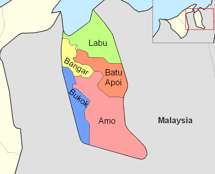
English: Map of the mukims (subdivisions) of the Temburong District of Brunei, in the northwest of the island of Borneo.
Created by Rarelibra 21:37, 11 September 2006 (UTC) for public domain use, using MapInfo Professional v8.5 and various mapping resources. |
| Ji̍t-kî | 2006年9-goe̍h11日 (原始上傳日期) |
| Chhut-chhù | Transferred from en.wikipedia to Commons by Xfigpower. |
| Chok-chiá | 英文Wikipedia的Rarelibra |
Siū-khoân
| 此作品已由其作者,英文Wikipedia的Rarelibra,釋出至公有領域。此授權條款在全世界均適用。 這可能在某些國家不合法,如果是的話: Rarelibra授予任何人有權利使用此作品於任何用途,除受法律約束外,不受任何限制。 |
原始上傳日誌
The original description page was here. All following user names refer to en.wikipedia.
- 2006-09-11 21:37 Rarelibra 1056×816×8 (19331 bytes) Map of the mukims of Temburong district of Brunei. Created by ~~~~ for public domain use, using MapInfo Professional v8.5 and various mapping resources.
Tóng-àn le̍k-sú
Chhi̍h ji̍t-kî/sî-kan, khoàⁿ hit sî-chūn--ê tóng-àn.
| Ji̍t-kî/Sî-kan | 細張圖 | 寸尺 | Iōng-chiá | Chù-kái | |
|---|---|---|---|---|---|
| hiān-chāi | 2011-nî 2-goe̍h 27-ji̍t (lé-pài) 08:59 | | 696 × 565(57 KB) | Naturals | color + change size and type of font |
| 2008-nî 7-goe̍h 3-ji̍t (pài-sì) 13:27 |  | 1,056 × 816(19 KB) | Xfigpower | {{Information |Description={{en|Map of the mukims of Temburong district of Brunei. Created by Rarelibra 21:37, 11 September 2006 (UTC) for public domain use, using MapInfo Professional v8.5 and various mapping resources.}} |Source=T |
Iáⁿ-siōng liân-kiat
Í-hā ê ia̍h liân kàu chit ê iáⁿ-siōng:
tóng-àn hō͘ lâng sái--ê chōng-hóng
Ē-kha--ê kî-thaⁿ wiki ēng tio̍h chit--ê tóng-àn:
- de.wikipedia.org hō͘ lâng ēng--ê chêng-hêng
- en.wikipedia.org hō͘ lâng ēng--ê chêng-hêng
- es.wikipedia.org hō͘ lâng ēng--ê chêng-hêng
- fa.wikipedia.org hō͘ lâng ēng--ê chêng-hêng
- frr.wikipedia.org hō͘ lâng ēng--ê chêng-hêng
- fr.wikipedia.org hō͘ lâng ēng--ê chêng-hêng
- hu.wikipedia.org hō͘ lâng ēng--ê chêng-hêng
- id.wikipedia.org hō͘ lâng ēng--ê chêng-hêng
- it.wikipedia.org hō͘ lâng ēng--ê chêng-hêng
- ja.wikipedia.org hō͘ lâng ēng--ê chêng-hêng
- ko.wikipedia.org hō͘ lâng ēng--ê chêng-hêng
- lt.wikipedia.org hō͘ lâng ēng--ê chêng-hêng
- nl.wikipedia.org hō͘ lâng ēng--ê chêng-hêng
- no.wikipedia.org hō͘ lâng ēng--ê chêng-hêng
- pl.wikipedia.org hō͘ lâng ēng--ê chêng-hêng
檢視此檔案的更多全域使用狀況。