tóng-àn:Two Harbors Minnesota aerial view.jpg
Seng khoàⁿ chiàm-liōng: 800 × 560 siōng-sò͘. Kî-thaⁿ--ê kái-sek-tō͘: 320 × 224 siōng-sò͘ | 640 × 448 siōng-sò͘ | 1,024 × 717 siōng-sò͘ | 1,280 × 896 siōng-sò͘ | 1,500 × 1,050 siōng-sò͘.
Choân kái-sek-tō͘ (1,500 × 1,050 siōng-sò͘ , tóng-àn chiàm-liōng: 674 KB, MIME luī-hêng: image/jpeg)
|
|
Che sī tùi Wikimedia Commons ín--lâi ê chi̍t hūn tóng-àn. I tī hia ê kì-su̍t-ia̍h téng-bīn ê chu-sìn hián-sī ùi ē-té. |
| Soat-bêng |
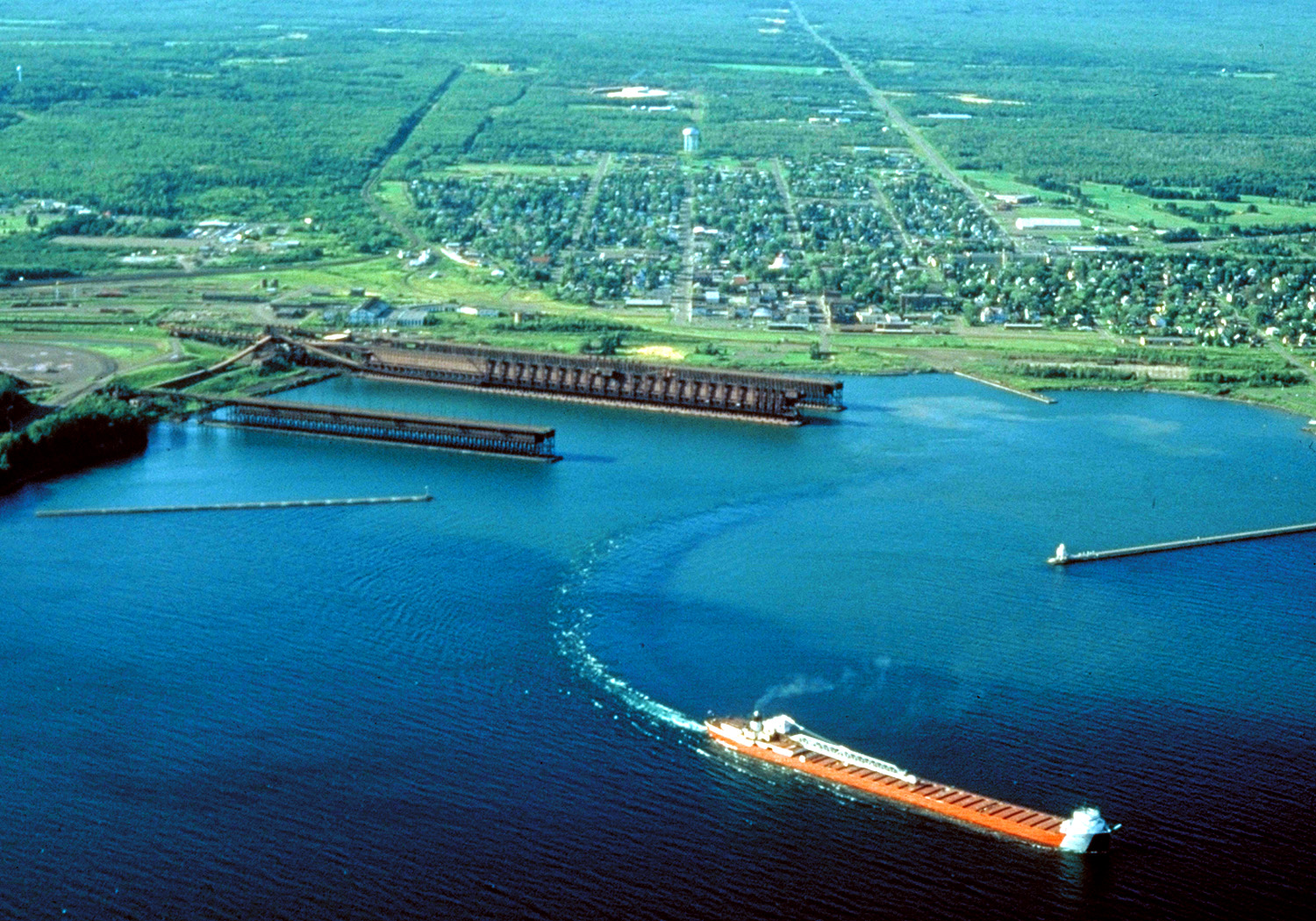
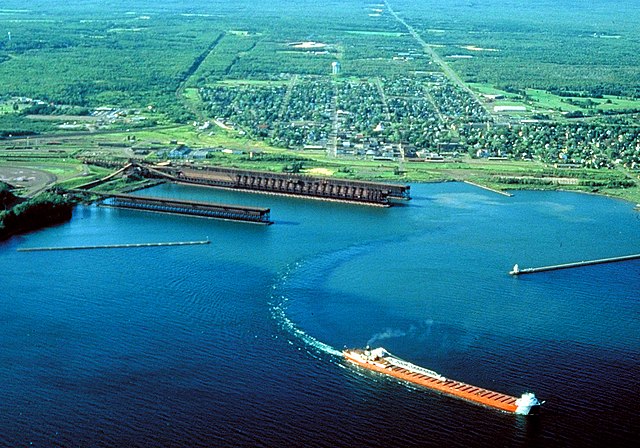
English: Aerial view of Two Harbors, Minnesota, on the north shore of Lake Superior. A Great lakes freighter is departing the harbor. |
|||
| Ji̍t-kî | not specified or unknown, though judging by the view and visuals of the photo, the photo appears to have been taken some time in the mid-late 1990s. | |||
| Chhut-chhù |
U.S. Army Corps of Engineers Digital Visual Library Image page Image description page Digital Visual Library home page |
|||
| Chok-chiá | U.S. Army Corps of Engineers, photographer not specified or unknown | |||
| 授權允准 (Bô siŏh-huòi sāi ciā ùng-giông) |
|
|||
| 圖中地點 | Two Harbors, Lake County, Minnesota, USA |
| 拍攝地點 | | 位於此地的本圖片與其他圖片: OpenStreetMap |
|---|
Tóng-àn le̍k-sú
Chhi̍h ji̍t-kî/sî-kan, khoàⁿ hit sî-chūn--ê tóng-àn.
| Ji̍t-kî/Sî-kan | 細張圖 | 寸尺 | Iōng-chiá | Chù-kái | |
|---|---|---|---|---|---|
| hiān-chāi | 2007-nî 3-goe̍h 30-ji̍t (pài-gō·) 03:30 | | 1,500 × 1,050(674 KB) | DanMS | {{Information | Description = {{en|Aerial view of Two Harbors, Minnesota, on the north shore of Lake Superior. A Great lakes freighter is departing the harbor.}} | Source = U.S. Army Corps of Engineers Digital Visual Library<br />[http://images |
Iáⁿ-siōng liân-kiat
Í-hā ê ia̍h liân kàu chit ê iáⁿ-siōng:
tóng-àn hō͘ lâng sái--ê chōng-hóng
Ē-kha--ê kî-thaⁿ wiki ēng tio̍h chit--ê tóng-àn:
- ar.wikipedia.org hō͘ lâng ēng--ê chêng-hêng
- arz.wikipedia.org hō͘ lâng ēng--ê chêng-hêng
- azb.wikipedia.org hō͘ lâng ēng--ê chêng-hêng
- ca.wikipedia.org hō͘ lâng ēng--ê chêng-hêng
- ceb.wikipedia.org hō͘ lâng ēng--ê chêng-hêng
- ce.wikipedia.org hō͘ lâng ēng--ê chêng-hêng
- de.wikipedia.org hō͘ lâng ēng--ê chêng-hêng
- en.wikipedia.org hō͘ lâng ēng--ê chêng-hêng
- en.wikivoyage.org hō͘ lâng ēng--ê chêng-hêng
- es.wikipedia.org hō͘ lâng ēng--ê chêng-hêng
- eu.wikipedia.org hō͘ lâng ēng--ê chêng-hêng
- fa.wikipedia.org hō͘ lâng ēng--ê chêng-hêng
- fr.wikipedia.org hō͘ lâng ēng--ê chêng-hêng
- he.wikipedia.org hō͘ lâng ēng--ê chêng-hêng
- ht.wikipedia.org hō͘ lâng ēng--ê chêng-hêng
- hu.wikipedia.org hō͘ lâng ēng--ê chêng-hêng
- ja.wikipedia.org hō͘ lâng ēng--ê chêng-hêng
- ky.wikipedia.org hō͘ lâng ēng--ê chêng-hêng
- lld.wikipedia.org hō͘ lâng ēng--ê chêng-hêng
- pl.wikipedia.org hō͘ lâng ēng--ê chêng-hêng
- pt.wikipedia.org hō͘ lâng ēng--ê chêng-hêng
- ru.wikipedia.org hō͘ lâng ēng--ê chêng-hêng
- sh.wikipedia.org hō͘ lâng ēng--ê chêng-hêng
- sr.wikipedia.org hō͘ lâng ēng--ê chêng-hêng
- sv.wikipedia.org hō͘ lâng ēng--ê chêng-hêng
- tt.wikipedia.org hō͘ lâng ēng--ê chêng-hêng
- uk.wikipedia.org hō͘ lâng ēng--ê chêng-hêng
- uz.wikipedia.org hō͘ lâng ēng--ê chêng-hêng
- vi.wikipedia.org hō͘ lâng ēng--ê chêng-hêng
- www.wikidata.org hō͘ lâng ēng--ê chêng-hêng
- zh.wikipedia.org hō͘ lâng ēng--ê chêng-hêng