tóng-àn:Union Pacific Railroad system map.svg

此 SVG 檔案的 PNG 預覽的大小:800 × 457 siōng-sò͘。 Kî-thaⁿ--ê kái-sek-tō͘: 320 × 183 siōng-sò͘ | 640 × 366 siōng-sò͘ | 1,024 × 585 siōng-sò͘ | 1,280 × 731 siōng-sò͘ | 2,560 × 1,463 siōng-sò͘ | 1,400 × 800 siōng-sò͘.
Choân kái-sek-tō͘ (SVG ùng-giông, chék-cháung: 1,400 × 800 chuông-só, ùng-giông duâi-nâung:1.56 MB)
|
|
Che sī tùi Wikimedia Commons ín--lâi ê chi̍t hūn tóng-àn. I tī hia ê kì-su̍t-ia̍h téng-bīn ê chu-sìn hián-sī ùi ē-té. |
Khài-iàu
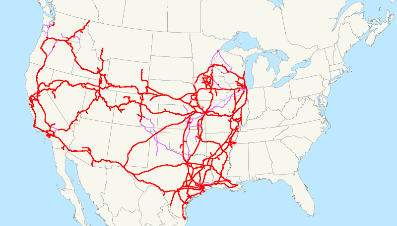
| Soat-bêng | This is a map of the Union Pacific Railroad as of 2008, with trackage rights in purple (the special Chicago-Kansas City intermodal trackage rights are lighter). Email me if you would like a copy of the GIS data I created (modified from Bureau of Transportation Statistics North American Transportation Atlas Data) or if you see any errors. |
| Ji̍t-kî | 2008年8-goe̍h26日 (原始上傳日期) |
| Chhut-chhù | No machine-readable source provided. Own work assumed (based on copyright claims). |
| Chok-chiá | No machine-readable author provided. NE2 assumed (based on copyright claims). |
Siū-khoân
| 我,此作品的版權所有人,釋出此作品至公共領域。此授權條款在全世界均適用。 這可能在某些國家不合法,如果是的話: 我授予任何人有權利使用此作品於任何用途,除受法律約束外,不受任何限制。 |
Tóng-àn le̍k-sú
Chhi̍h ji̍t-kî/sî-kan, khoàⁿ hit sî-chūn--ê tóng-àn.
| Ji̍t-kî/Sî-kan | 細張圖 | 寸尺 | Iōng-chiá | Chù-kái | |
|---|---|---|---|---|---|
| hiān-chāi | 2009-nî 3-goe̍h 18-ji̍t (pài-saⁿ) 04:52 | | 1,400 × 800(1.56 MB) | NE2 | Verifying that nothing has gotten screwed up. |
| 2009-nî 2-goe̍h 23-ji̍t (pài-it) 13:08 |  | 1,400 × 800(1.54 MB) | NE2 | Changed the display of lines owned by the government for the purposes of passenger rail, so that if UP is the primary freight operator it is not shown as trackage rights. | |
| 2009-nî 1-goe̍h 15-ji̍t (pài-sì) 11:03 |  | 1,400 × 800(1.51 MB) | NE2 | Just checking that I haven't lost any data over the months. | |
| 2008-nî 8-goe̍h 26-ji̍t (pài-jī) 23:09 |  | 1,120 × 640(1.47 MB) | NE2 | == Summary == This is a map of the Union Pacific Railroad as of 2008, with w:trackage rights in purple (the special Chicago-Kansas City intermodal trackage rights are lighter). Email me if you would like a copy of the GIS d |
Iáⁿ-siōng liân-kiat
Í-hā ê ia̍h liân kàu chit ê iáⁿ-siōng:
tóng-àn hō͘ lâng sái--ê chōng-hóng
Ē-kha--ê kî-thaⁿ wiki ēng tio̍h chit--ê tóng-àn:
- da.wikipedia.org hō͘ lâng ēng--ê chêng-hêng
- de.wikipedia.org hō͘ lâng ēng--ê chêng-hêng
- en.wikipedia.org hō͘ lâng ēng--ê chêng-hêng
- eo.wikipedia.org hō͘ lâng ēng--ê chêng-hêng
- es.wikipedia.org hō͘ lâng ēng--ê chêng-hêng
- fa.wikipedia.org hō͘ lâng ēng--ê chêng-hêng
- fi.wikipedia.org hō͘ lâng ēng--ê chêng-hêng
- fr.wikipedia.org hō͘ lâng ēng--ê chêng-hêng
- he.wikipedia.org hō͘ lâng ēng--ê chêng-hêng
- hu.wikipedia.org hō͘ lâng ēng--ê chêng-hêng
- id.wikipedia.org hō͘ lâng ēng--ê chêng-hêng
- it.wikipedia.org hō͘ lâng ēng--ê chêng-hêng
- ja.wikipedia.org hō͘ lâng ēng--ê chêng-hêng
- ko.wikipedia.org hō͘ lâng ēng--ê chêng-hêng
- ms.wikipedia.org hō͘ lâng ēng--ê chêng-hêng
- mt.wikipedia.org hō͘ lâng ēng--ê chêng-hêng
- nl.wikipedia.org hō͘ lâng ēng--ê chêng-hêng
- no.wikipedia.org hō͘ lâng ēng--ê chêng-hêng
- pl.wikipedia.org hō͘ lâng ēng--ê chêng-hêng
- pt.wikipedia.org hō͘ lâng ēng--ê chêng-hêng
- ro.wikipedia.org hō͘ lâng ēng--ê chêng-hêng
- ru.wikipedia.org hō͘ lâng ēng--ê chêng-hêng
- simple.wikipedia.org hō͘ lâng ēng--ê chêng-hêng
- sk.wikipedia.org hō͘ lâng ēng--ê chêng-hêng
- sv.wikipedia.org hō͘ lâng ēng--ê chêng-hêng
- uk.wikipedia.org hō͘ lâng ēng--ê chêng-hêng
- www.wikidata.org hō͘ lâng ēng--ê chêng-hêng
- zh.wikipedia.org hō͘ lâng ēng--ê chêng-hêng