Lidar
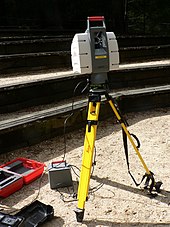
Lidar (ing-gú: Lidar /ˈlaɪdɑːr/, iah kiò-tsò LIDAR, hi̍k-tsiá LiDAR; ū-tang-sî-á kiò-tsò LADAR; Kong-ha̍k luî-ta̍t) sī "Kong-kiám kah tshik-kū"[1] hi̍k-tsiá "kik-kong sîng-siōng, kiám-tshik kah tshik-kū" ê sok-siá.[2] Lidar sī -tsióng tsi̍t thong-kuè iōng kik-kong biâu-tsún bu̍t-thé hi̍k-tsiá piáu-bīn, lî-tshiánn tshik-liông huán-siā-kng huán-tńg--lâi tsiap-siu-khì ê sî-kan lâi khak-tīng huān-uî (pīng-tshiánn ē-tàng kái-piàn kī-lî) ê hong-huat. Lidar ū-tang-sî-á hông kiò-tsò 3-D kik-kong sàu-biâu, sī 3-D sàu-biâu hām kik-kong sàu-biâu ê ti̍k-sû tsoo-ha̍p.[3] Lidar kū-iú tē-bīn, ki-tsài kah î-tōng ê ìng-iōng.[4][5]


Lidar thong-siông iōng-teh tsè-tsō ko hun-piān-lu̍t tē-tôo, teh tshik-liông, tāi-tē tshik-liông-ha̍k, tshik-huē-ha̍k, khó-kóo-ha̍k, tē-lí-ha̍k, tē-tsit-ha̍k, tē-māu-ha̍k, tē-tsìn-tōng-ha̍k, lîm-gia̍p, tāi-khì bu̍t-lí-ha̍k,[6] luî-siā tsè-tō, "ki-tsài kik-kong ki-tshik-huē" (ALSM) kah kik-kong tshik-kuân. Lidar iah-koh ū iōng-teh bóo tsi̍t-kuá-á tsú-tōng kà-sú khì-tshia[7] ê khòng-tsè hām tō-hâng; í-ki̍p teh hué-tshenn tē-hîng tíng-kuân tshòng-kì-lio̍k hui-hîng ê Ingenuity ti̍t-sing-ki.[8]
Tsù-kái
siu-kái- ↑ National Oceanic and Atmospheric Administration (26 February 2021). "What is LIDAR". oceanservice.noaa.gov (ēng Eng-gí). US Department of Commerce. 15 March 2021 khòaⁿ--ê.
- ↑ Travis S. Taylor (2019). Introduction to Laser Science and Engineering. CRC Press.
- ↑ Jie Shan and Charles K. Toth (2018). Topographic Laser Ranging and Scanning: Principles and Processing (2nd ed.). CRC Press.
- ↑ "Adoption of gallium-based lidar sensors gathers pace". www.argusmedia.com (ēng Eng-gí). 2021-06-29. goân-loē-iông tī 2021-07-14 hőng khó͘-pih. 2021-07-14 khòaⁿ--ê.
- ↑ "Ecologists compare accuracy of Lidar technologies for monitoring forest vegetation: Findings suggest mobile platforms have great potential for monitoring a variety of forest attributes". ScienceDaily (ēng Eng-gí). 2021-07-14 khòaⁿ--ê.
- ↑ Cracknell, Arthur P.; Hayes, Ladson (2007) [1991]. Introduction to Remote Sensing (2 pán.). London: Taylor and Francis. ISBN 978-0-8493-9255-9. OCLC 70765252.
- ↑ Lim, Hazel Si Min; Taeihagh, Araz (2019). "Algorithmic Decision-Making in AVs: Understanding Ethical and Technical Concerns for Smart Cities". Sustainability (ēng Eng-gí). 11 (20): 5791. arXiv:1910.13122 . doi:10.3390/su11205791.
- ↑ "How NASA Designed a Helicopter That Could Fly Autonomously on Mars". IEEE Spectrum. 17 February 2021. goân-loē-iông tī 19 February 2021 hőng khó͘-pih. 19 February 2021 khòaⁿ--ê.
Ên-sin ua̍t-to̍k
siu-kái- Gil, Emilio; Llorens, Jordi; Llop, Jordi; Fàbregas, Xavier; Gallart, Montserrat (2013). "Use of a Terrestrial LIDAR Sensor for Drift Detection in Vineyard Spraying". 'nsors. 13 (1): 516–534. doi:10.3390/s130100516. ISSN 1424-8220. PMC 3574688. PMID 23282583.
- Heritage, E. (2011). 3D laser scanning for heritage. Advice and guidance to users on laser scanning in archaeology and architecture. Available at www.english-heritage.org.uk. 3D Laser Scanning for Heritage | Historic England
- Heritage, G., & Large, A. (Eds.). (2009). Laser scanning for the environmental sciences. John Wiley & Sons. ISBN 1-4051-5717-8
- Maltamo, M., Næsset, E., & Vauhkonen, J. (2014). Forestry Applications of Airborne Laser Scanning: Concepts and Case Studies (Vol. 27). Springer Science & Business Media. ISBN 94-017-8662-3
- Shan, J., & Toth, C. K. (Eds.). (2008). Topographic laser ranging and scanning: principles and processing. CRC press. ISBN 1-4200-5142-3
- Vosselman, G., & Maas, H. G. (Eds.). (2010). Airborne and terrestrial laser scanning. Whittles Publishing. ISBN 1-4398-2798-2
Tsham-ua̍t
siu-kái- Khì-siōng gî-khì
- Atomic line filter – Optical band-pass filter used in the physical sciences
- Ceilometer – Ground-based lidar for cloud height measurement
- Clear-air turbulence – Turbulent movement of transparent air masses without any visual cues
- CLidar
- Geodimeter
- Geological structure measurement by LiDAR – Terrain measurement with light beams
- Laser rangefinder – Range finding device that uses a laser beam to determine the distance to an object
- LAS file format
- libLAS – BSD-licensed C++ library for reading/writing ASPRS LAS lidar data
- Lidar detector
- List of laser articles
- National lidar dataset (all countries)
- National Lidar Dataset (United States)
- Optech
- Optical heterodyne detection
- Optical time-domain reflectometer
- Photogrammetry – Taking measurements using photography
- Range imaging – Technique which produces a 2D image showing the distance to points in a scene from a specific point
- Satellite laser ranging
- Seafloor mapping#LiDAR
- SODAR
- Time-domain reflectometry
- TopoFlight
Guā-pōo liân-kiat
siu-kái- National Oceanic and Atmospheric Administration (NOAA) (15 April 2020). "What is LIDAR?". NOAA's National Ocean Service.
- The USGS Center for LIDAR Information Coordination and Knowledge (CLICK) – A website intended to "facilitate data access, user coordination and education of lidar remote sensing for scientific needs."